Recapping the active 2024 Atlantic hurricane season as it comes to a close
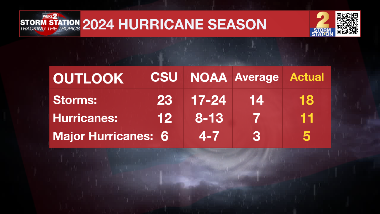
The 2024 Atlantic Hurricane Season wrapped up on Saturday. It was an active season to say the least. In total, eighteen named storms developed and tracked through the Atlantic Basin. Of those, eleven became hurricanes and five became major (Cat. 3+) hurricanes. An average season produces fourteen named storms, seven hurricanes, and three major hurricanes.
The seasonal activity fell within the forecasted ranges from the National Oceanic and Atmospheric Administration (NOAA). While Colorado State University's forecast of 23 named storms was a tad high, the projected number of hurricanes and major hurricanes were each within one of the actual value.

TWO BURSTS OF ACTIVITY
Activity began on June 19 with the formation of Tropical Storm Alberto in the Bay of Campeche. It was off to the races after that, with four additional named systems developing through mid-August.
Then, the tropics closed for business. From August 13 through September 8, no systems formed in the Atlantic - for the first time in over 50 years. Such a lull was likely caused by a combination of factors, a few of which include:
1) A northward shift in the track of tropical waves coming off the African Coast: These waves commonly serve as "seeds" for tropical development. Such a shift causes these "seeds" to move over cooler waters to the north, preventing additional development
Trending News
2) Abnormally warm upper-level temperatures: Even with record-warm ocean temperatures, the amount of warmth in the upper atmosphere limited the amount of instability, or storm energy, which hurricanes require.
3) Too much wind shear in the eastern/central Atlantic: Such conditions work against hurricane development by disrupting its structure.
Hurricane Francine broke the period of silence once it formed on September 9, just before the peak of hurricane season. Twelve named storms formed after peak season, seven of which were hurricanes - the most on record for this period. The season finally quieted down with the dissipation of Tropical Storm Sara on November 18.
LANDFALLING SYSTEMS
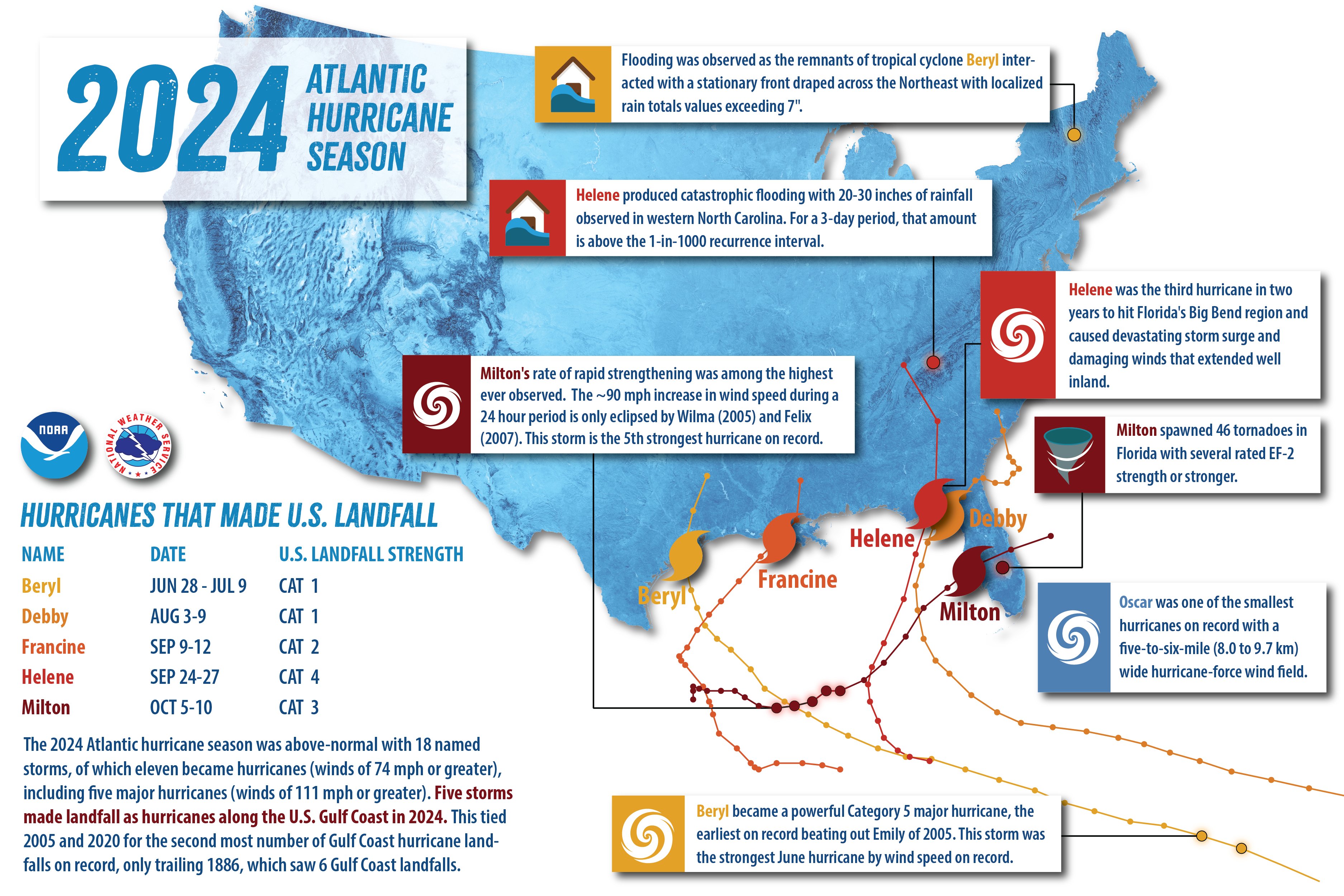
Five hurricanes made landfall in the Lower 48 in 2024, with two storms doing so as major hurricanes. It is worth nothing that all of these landfalls occurred along the Gulf Coast. This ties 2005 and 2020 for the second most number of Gulf Coast hurricane landfalls on record, trailing behind 1886 which saw six.
Hurricane Beryl: Was a Category 5 hurricane with maximum sustained winds at 165 mph at peak strength. Beryl was the earliest Category 5 on record in the Atlantic basin. Beryl made three landfalls, its first in the island of Carriacou, Grenada. A second landfall occurred a few days later in the Yucatan Peninsula, with the third and final one occurring near Matagorda, Texas. Beryl was responsible for significant storm surge flooding across parts of Texas and Louisiana, as well as 68 tornadoes across the country.
Hurricane Debby: Was a Category 1 hurricane with maximum sustained winds at 80 mph at peak strength. Debby made landfall on August 5 in Florida's Big Bend Region at that intensity, and was the first of two storms to do so this year. The storm was slow-moving and took an erratic path, eventually reemerging over open water along the Southeast Coast before making a second landfall in South Carolina on August 8. Debby was responsible for widespread flooding across the Southeast and parts of Canada. In fact, the system became the costliest natural disaster in the history of the Canadian province of Quebec.
Hurricane Francine: Was a Category 2 hurricane with maximum sustained winds at 100 mph at peak strength. The storm made landfall in Terrebonne Parish on September 11 at that intensity before tracking inland between Baton Rouge and New Orleans. Terrebonne and Lafourche Parishes took the hardest hit from Francine. Damage is estimated at $1.5 billion. Fortunately, the storm resulted in no fatalities.
Hurricane Helene: Was a Category 4 hurricane with maximum sustained winds at 140 mph at peak strength. Helene made landfall on September 26 in Florida's Big Bend Region at that intensity, and was the second storm of the season to do so. The storm caused catastrophic flooding and widespread wind damage from the Gulf Coast to the southern Appalachians. Damages are estimated unofficially at >$120 billion. Helene is responsible for more than 150 direct fatalities - the deadliest to affect the mainland U.S. since Hurricane Katrina in 2005.
Hurricane Milton: Was a Category 5 hurricane with maximum sustained winds at 180 mph at peak strength. In fact, Milton attained Category 5 strength twice during its life cycle. Milton's rapid intensification rate was also one of the highest ever recorded, strengthening by 90 mph in a 24-hour period from October 6 to 7. The storm made landfall near Siesta Key, Florida on October 9 as a major Category 3 storm, bringing torrential rainfall and a destructive storm surge to parts of the state. Milton was also responsible for 46 tornadoes in Florida.

For now, the Capital Area can turn its attention away from the tropics. The 2025 Atlantic Hurricane Season starts up on June 1 - the Storm Station will be ready to keep you informed once that time arrives.


