

Latest Weather Blog
Tracking Tropical Storm Bertha, Extreme Heat Warning issued for Metro Baton Rouge
Tropical Storm Bertha is moving toward the northwest and beginning to turn westward, with tropical storm conditions already spreading across parts of the Florida Panhandle. As of 1 p.m. CDT, Bertha was located about 90 miles southwest of Panama City, Florida, and about 125 miles southeast of Mobile, Alabama. The storm is moving northwest at 5 mph with maximum sustained winds near 60 mph. The storm has likely reached peak intensity and will weaken over the next few days due to interaction with land, dry air, and wind shear.
A turn toward the west-northwest and then west is expected later Tuesday, with a continued westward motion forecast through Friday. Bertha is expected to move near or along the northern Gulf Coast over the next few days. A Tropical Storm Warning is in effect from the Bay/Gulf County Line in Florida to the Terrebonne/Lafourche Parish Line in Louisiana. A Tropical Storm Watch covers areas west of the Terrebonne/Lafourche Parish Line to the Vermilion/Cameron Parish Line in Louisiana, as well as metropolitan New Orleans, Lake Pontchartrain and Lake Maurepas.
Outer rainbands began over south Louisiana on Tuesday afternoon and will stick around on an off-and-on basis through Thursday. There will be a lot of dry time as the storm passes. Up to 4 inches of rain may occur along the immediate coast with higher amounts offshore. Further inland, north of I-10, rainfall totals will be much lower, with most recording around an inch. It is even possible that one or two spots do not get any rain at all.
Storm surge is also a concern along the coast. The combination of surge and tide could cause normally dry areas near the immediate coast to flood, with water potentially reaching 2 to 4 feet above ground from the mouth of the Mississippi River to the Mississippi/Alabama border. Other areas, including Lake Pontchartrain and parts of the Louisiana coast, could see 1 to 3 feet of surge. Swells from Bertha are spreading westward along the northern Gulf Coast and are likely to create life-threatening surf and rip current conditions over the next few days.
While winds will be relatively minor with the storm, locations near the coast could experience some gusts near tropical storm strength which is 39 mph. Further inland, breezes are not expected to blow higher than 10-20 mph except with higher gusts in thunderstorms.

Trending News
An EXTREME HEAT WARNING is set to take effect from 10 a.m. to 8 p.m. Wednesday for portions of southeast Louisiana and southern Mississippi. Dangerously hot conditions are possible with heat index values expected to reach up to 115. That kind of heat and high humidity can cause heat illnesses. Drink plenty of fluids, stay in an air-conditioned room and stay out of the sun when possible. Those who do go outside should wear lightweight and loose-fitting clothing and try to limit strenuous activities to early morning or evening.
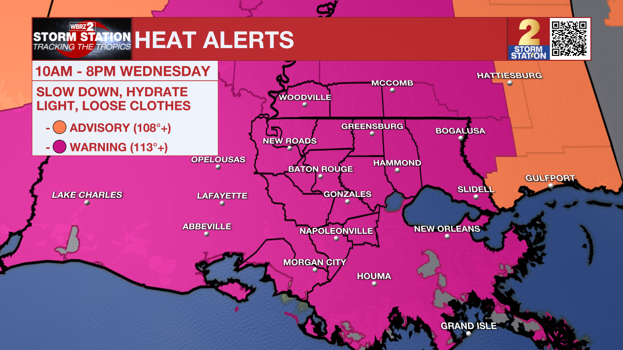
Tonight & Tomorrow: The bulk of the showers and thunderstorms will trend down overnight, but some spotty activity will remain possible. With ample tropical humidity in place, which causes temperatures to struggle to cool down at night, lows will go no lower than the upper 70s. Despite Bertha making a closer pass to the state on Wednesday, there may actually be less rain around than Tuesday due to the lopsided, unorganized nature of the system. Still, isolated showers and thunderstorms will be possible. The greater impact for most will be heat. Some of the highest feels-like temperatures of the season are expected as highs in the mid 90s and tropical humidity send the heat index as high as 113 degrees. An EXTREME HEAT WARNING has been issued for all of Metro Baton Rouge.

Up Next: Periodic tropical downpours will continue through Thursday, especially south of I-10. Outside of these showers, intense heat and humidity will dominate. As the tropical system pulls away late in the week and into the weekend, the summer heat will continue to bake the Capital Area.

The Tropics: Elsewhere in the basin, all is quiet. No additional development is expected in the Gulf, Caribbean or Atlantic.
Get the latest 7-day forecast and real-time weather updates HERE.
Watch live news HERE.
— The Storm Station Meteorologists
The Storm Station is here for you, on every platform. Your weather updates can be found on News 2, wbrz.com, and the WBRZ WX App on your Apple or Android device. Follow WBRZ Weather on Facebook and X for even more weather updates while you are on the go.
More News

