

Latest Weather Blog
Saturday PM Forecast: Cool, Dry Weather Takes Hold
A strong cold front has brought a welcome change to South Louisiana, replacing summer-like heat with cooler temperatures and much lower humidity. Clear skies and dry weather will continue through the weekend and into next week, although drought and fire danger remain concerns.

Tonight & Sunday: Clear skies and cooler air will make for a comfortable Saturday night across the Capital Region, with temperatures falling into the 40s and 50s. Winds will gradually ease, though some breezy conditions may linger.

Use the slider to advance through the next 24 hours of Futurecast
Sunday brings plenty of sunshine, low humidity, and highs in the upper 70s to lower 80s. It will be a pleasant fall day, with no rain expected.
Trending News
Up Next: The dry pattern continues through much of next week as high pressure keeps rain chances near zero. Temperatures will gradually climb above normal again, but overnight lows will rise to the 50s and 60s.
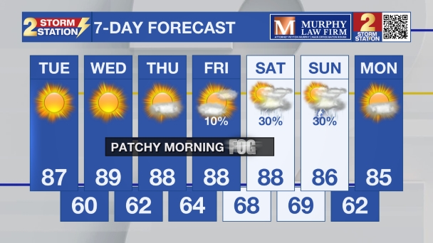
Drought conditions will remain a concern. Dry vegetation and occasional breezes can allow fires to spread, so caution is still needed with outdoor burning even after any Red Flag Warning expires. Winds over the Gulf waters will also take longer to settle down, with marine advisories potentially continuing into the new workweek.

Tropics: The National Hurricane Center does not expect tropical cyclone formation anywhere in the Atlantic basin over the next seven days.
- Dave
Get the latest 7-day forecast and real-time weather updates HERE.
Watch live news HERE.
The Storm Station is here for you, on every platform. Your weather updates can be found on News 2, wbrz.com, and the WBRZ WX App on your Apple or Android device. Follow WBRZ Weather on Facebook and X for even more weather updates while you are on the go.
More News

