

Latest Weather Blog
Sunday PM Forecast: Storms igniting each afternoon, system organizing in the tropics
An uptick in available moisture will fuel afternoon thunderstorms through much of next week. Although there will be plenty of dry time, a few storms could affect commutes and after-school activities. In the tropics, the next system is taking shape.
Tonight & Tomorrow: Leftover afternoon storms will fizzle fast as the evening sets in. The rest of the night looks mainly clear with lows on pace with average in the mid-70s. By morning, storms may already be underway along the coast. As was the case on Sunday, this activity could send clouds drifting into the Metro Area early in the day. Depending on their thickness, temperatures might be slow to rise at first. However, the sun will eventually take over, pushing highs into the low 90s by afternoon. That would be warm enough to spark isolated thunderstorms, which will be hit-or-miss in nature. Be prepared for the possibility of storms overlapping with the afternoon commute and after-school activities.
Up Next: For the time being, tropical moisture will maintain a presence across the region. This will fuel scattered thunderstorms through midweek, with the bulk of the action centered on the afternoons. Temperatures will hold steady, with highs reaching the low 90s and lows dipping into the mid-70s. By late week and the weekend, rain chances will ease into the isolated category. Though the coverage of storms will lower, that doesn’t mean every spot will be rain-free. But with fewer storms around, highs will respond by creeping into the mid-90s by the weekend.
The Tropics: The primary area of interest across the entire basin is an area of low pressure situated between the west coast of Africa and Cabo Verde Islands. Associated showers and thunderstorms have continued to show signs of organization. It won’t take much more to lead to the formation of a tropical depression. That could happen if a small increase in the system’s organization is observed in the next day or so. Even if it doesn’t happen in the next 24-48 hours, development is still likely to take place later in the week as the system drifts west through the tropical Atlantic. The next name up on the list is Erin.
Steering winds will guide the disturbance westward in the meantime, but confidence in the system's motion will fade as it nears the Leeward Islands late in the week. All options are on the table after that, including a turn out to sea as well as a westward track into the Gulf. It’s still too far out to speculate on any potential U.S. impacts — if they occur at all. For now, this system is simply one to watch; there is no imminent threat at this time. Check back with the Storm Station for future updates.
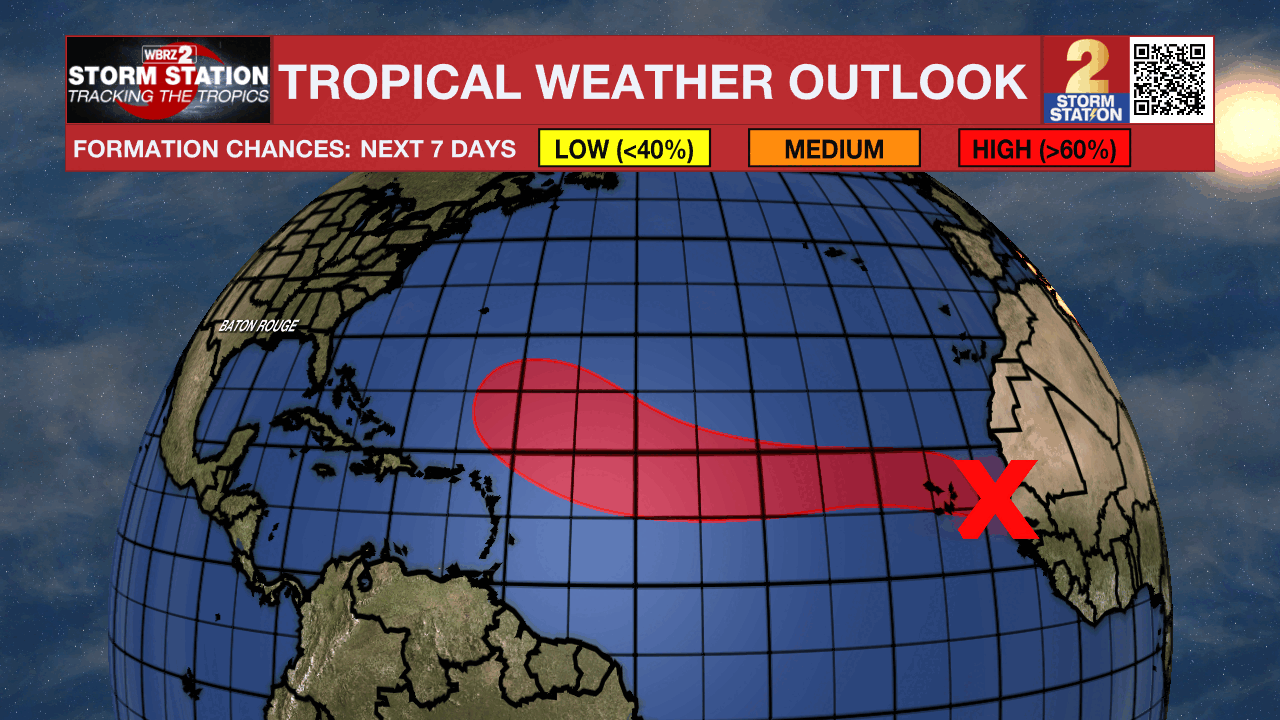
Meanwhile, another area of thunderstorms is located farther north over the central tropical Atlantic. While gradual development is possible around midweek, overall odds appear low at this time. This system will not be a threat to land.
Trending News
Get the latest 7-day forecast and real-time weather updates HERE.
Watch live news HERE.
— Meteorologist Malcolm Byron
The Storm Station is here for you, on every platform. Your weather updates can be found on News 2, wbrz.com, and the WBRZ WX App on your Apple or Android device. Follow WBRZ Weather on Facebook and X for even more weather updates while you are on the go.
More News
