

Latest Weather Blog
Sunday PM Forecast: Summer holds on as fall begins; cold front to shake things up
As fall begins, summer will still be in charge. However, a cold front will help loosen summer's grip by midweek. That will come with an uptick in showers and storms, signaling cooler and drier air close behind.
Tonight & Tomorrow: Leftover showers and storms will taper through the evening. Although a stray shower cannot be ruled out overnight, most areas will trend drier. Expect a few passing clouds with lows in the lower 70s by morning. Monday marks the beginning of astronomical fall, but summer’s grip will still linger. Look for a high in the low 90s with humidity on the rise, at least as compared to what was felt over the weekend. The combination of warmth and humidity should fuel a round of isolated showers and thunderstorms. While not a washout, spotty downpours could briefly disrupt outdoor plans — so keep an umbrella nearby.
Up Next: Tuesday’s weather will look much like Monday’s — warm, humid, with isolated thunderstorms. A more significant change comes around midweek as a cold front moves into the region. Clouds will increase on Wednesday, with scattered storms possible. The nearby front will maintain a chance for showers and storms even after dark. Until the front clears the region, which appears likely at this point, rain will remain in the forecast. The latest data suggest a frontal passage by Thursday night, making way for a slightly cooler and more pleasant weekend with highs in the upper 80s and lows in the mid-60s. Until then, expect warm and muggy conditions.
The Tropics: Gabrielle became a hurricane on Sunday afternoon, as confirmed by NOAA Hurricane Hunter observations. Steady to rapid intensification is possible over the next day or so. The latest forecast calls for a major Category 3 hurricane by Monday night. Gabrielle will make an eastward turn during this timeframe, narrowly missing Bermuda. Gabrielle is forecast to slowly weaken thereafter. But even so, the storm might affect the Azores as a tropical storm by late week.

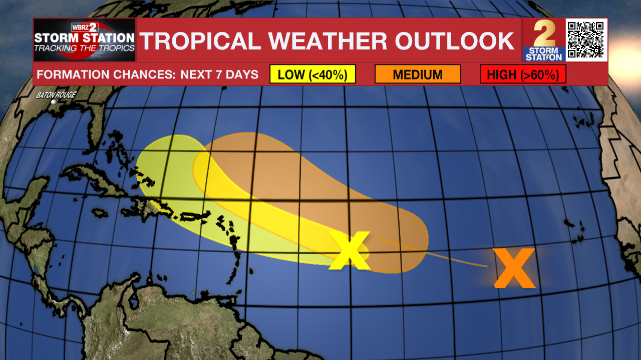
Meanwhile, there are two other areas to monitor:
Central Tropical Atlantic – A broad tropical wave is producing limited showers and thunderstorms well to the west-southwest of the Cabo Verde Islands. Although conditions are not favorable for tropical development over the next day or two, that could change later in the week. A tropical depression could form while the system continues northwestward across the central Atlantic. Development odds are at ~60% as of Sunday evening.
Trending News
East of the Windward Islands – Another tropical wave located more than 500 miles east of the Windward Islands is producing a small and disorganized area of thunderstorms. Satellite data indicate that the wave does not have a closed circulation. Conditions are only slightly favorable for additional development. Overall, tropical formation odds are low as of Sunday evening. Regardless of development, the system is expected to bring gusty winds and showers for portions of the Leeward Islands on Tuesday.
Get the latest 7-day forecast and real-time weather updates HERE.
Watch live news HERE.
— Meteorologist Malcolm Byron
The Storm Station is here for you, on every platform. Your weather updates can be found on News 2, wbrz.com, and the WBRZ WX App on your Apple or Android device. Follow WBRZ Weather on Facebook and X for even more weather updates while you are on the go.
More News
