

Latest Weather Blog
Thursday PM Forecast: Familiar August pattern brings heat and a few storms
The classic August weather continues with hot, humid afternoons and only limited rain chances. While storm coverage may tick up slightly this weekend and early next week, widespread washouts are not anticipated.
Tonight & Tomorrow: The typical August pattern holds steady. After a few evening storms, skies will clear overnight with lows dipping to around 73°. The morning brings warm and muggy conditions, but otherwise, not much weather to worry about. Temperatures will climb into the low 90s by the afternoon, and with high humidity, it will feel more like the triple digits. Yes, it’s hot—but not nearly as oppressive as what we dealt with a few weeks ago. As for rain, don’t expect much. Coverage will be limited, with only a few stray showers or storms possible.
Up Next: The next 7 days will stick with the familiar pattern: hot, humid afternoons with pop-up storms. The main day-to-day difference will be how many storms we see. This weekend brings a slight uptick in activity, with isolated showers and storms expected—though many spots will still stay dry. Early next week, atmospheric moisture peaks, leading to better chances for scattered storms. While some areas will see downpours, widespread washouts aren’t likely. Storm coverage will gradually taper off by mid to late week as high pressure starts to build back in.
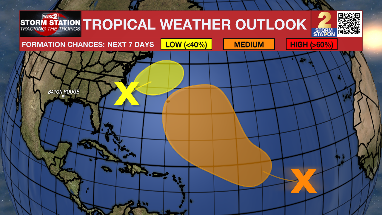
The Tropics: Dexter has lost its tropical characteristics, and is now a post-tropical storm. The system will completely diminish by the start next week. There are no coastal watches or warnings in effect, and it poses no immediate hazards to land.
Trending News
A non-tropical area of low pressure is expected to form over the next day or two, a few hundred miles offshore of North Carolina. Some tropical or subtropical development is possible this weekend while the system moves northeastward over the warm waters of the Gulf Stream, off the east coast of the United States. By early next week, the low is expected to reach colder water and more hostile conditions, ending its chance for tropical or subtropical development.
A tropical wave over the central tropical Atlantic is producing disorganized shower activity. Environmental conditions are forecast to become more conducive for gradual development in a few days, and a tropical depression could form late this weekend or early next week while the system moves west-northwestward to northwestward across the central tropical and subtropical Atlantic.
Get the latest 7-day forecast and real-time weather updates HERE.
Watch live news HERE.
– Balin
The Storm Station is here for you, on every platform. Your weather updates can be found on News 2, wbrz.com, and the WBRZ WX App on your Apple or Android device. Follow WBRZ Weather on Facebook and X for even more weather updates while you are on the go.
More News
