

Latest Weather Blog
Thursday PM Forecast: front brings football weather to Capital City
The Capital Area is kicking off a stretch of pleasant weather with long-awaited cooler, drier air. Mainly clear and comfortable conditions will prevail well into next week.
Tonight & Tomorrow: Overnight will be mainly clear and comfortably cool with a low near 61 degrees. Friday will see a slightly lower high than earlier in the week, around 84 degrees. You might notice a few more clouds around than on Thursday, but they will not produce any rain.
Friday Night Blitz: A near-perfect night is setting up for high school football! Under clear skies, temperatures will be dropping through the 70s during the games. Expect kickoff temperatures in the upper 70s, falling into the low 70s by the fourth quarter.
The Weekend: The trend of low humidity and slightly cooler temperatures will hold strong through the weekend. The afternoon high temperatures will be right in that seasonable mid-80s range under mostly sunny skies. Overnight lows will remain comfortable in the low 60s. An interesting detail to watch will be whether or not Metro Airport at Baton Rouge can slip to 59 degrees or lower on Saturday or Sunday morning. If not, it is very likely that 2025 will set the record for the latest date into the fall season for first temperatures in the 50s.
Trending News
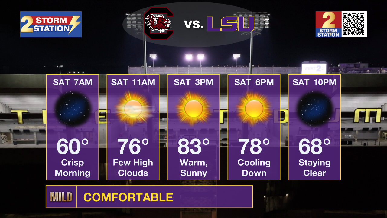
LSU Homecoming: Tailgating temperatures on Saturday will start off crisp and cool in the low 60s, then move to comfortably warm, with highs in the mid 80s, with that low humidity. For the 6:45 p.m. kickoff, the weather will be ideal. Expect temperatures in the upper 70s at kickoff, steadily cooling into the upper 60s by the time the fourth quarter rolls around.

Southern on the Road: The Jags travel to Daytona Beach, Florida, to take on Bethune-Cookman at 2:00 p.m. on Saturday. The weather will be a factor as winds will be sustained over 20mph and gust over 30mph during the game. A few passing showers are even possible. Temperatures will be in the upper 70s during most of the game.
Up Next: Looking ahead to next week, you'll start to feel things warm back up a bit. Highs will gradually climb, reaching 87 degrees on Monday, 88 degrees on Tuesday, and 89 degrees on Wednesday. We'll also see those overnight lows creep up slightly, eventually hitting 64 by Thursday morning. While it won't be as cool as this weekend, the dry conditions will hold, meaning the sunshine will dominate and you won't have to worry about rain.

The Tropics: Tropical Storm Jerry is expected to pass near or northeast of the northern Leeward Islands this evening and tonight, with maximum sustained winds of 65 mph. Tropical Storm Warnings are in effect for Barbuda, Anguilla, St. Barthelemy, St. Martin, and Sint Maarten. The main hazards include high winds and 2 to 4 inches of rain, which poses a flash flooding risk for the Leeward and Virgin Islands. Jerry is forecast to strengthen and could become a hurricane by late Friday or Saturday. The storm will then move north and eventually northeast out to sea.
Get the latest 7-day forecast and real-time weather updates HERE.
Watch live news HERE.
– Josh
The Storm Station is here for you, on every platform. Your weather updates can be found on News 2, wbrz.com, and the WBRZ WX App on your Apple or Android device. Follow WBRZ Weather on Facebook and X for even more weather updates while you are on the go.
More News
