

Latest Weather Blog
Tuesday AM Forecast: Cold front brings stormy weather, then a refreshing feel
The first full week of fall will deliver a lot of changing weather conditions. We will start off with humidity and increasing storm chances. The week will end with slightly lower temperatures.
Today & Tonight: A rinse and repeat forecast is in store for your Tuesday. Expect highs in the 90s, humidity, and isolated storms, mainly in the PM hours. A handful will receive measurable rainfall, but many others will miss out on the storms. Just keep an eye to the sky if you have outdoor plans. Overnight, we will clear out, with muggy lows near 74 degrees.
The Next Impact: A broad storm system sweeping across the U.S. will send a cold front down to the Gulf Coast by midweek. That boundary is expected to reach our area Wednesday, bringing more clouds and a jump in shower and thunderstorm coverage. Scattered storms should break out Wednesday afternoon, with activity becoming more numerous into Thursday. Even the overnight hours won’t be completely dry as the front hangs nearby. Rain chances will stick around until the boundary finally pushes through, likely sometime Thursday.
Between Wednesday and Thursday, most spots will collect around 1–2 inches of rain—enough to make up for moisture lost to recent evaporation, though not nearly enough to put a dent in longer-term dryness. The rainfall will at least help slow drought expansion for now. A few stronger storms could also flare up, with damaging wind gusts being the primary concern, though those would be isolated.
The Weekend: After the front moves out, a stretch of drier and slightly cooler air will settle in. Temperatures won’t be “cool” but compared to the recent heat, it will feel like a break. Highs should level off in the mid to upper 80s, while overnight lows dip into the mid 60s—right around, or just a touch under, seasonal norms. The lower humidity will make the difference, setting up a more comfortable weekend that’s perfect for spending time outdoors.
The Tropics: Hurricane Gabrielle still looks powerful on satellite, but signs point to it peaking in strength. The eye has become less clear and the storm’s core less organized, likely due to stronger upper-level winds starting to disrupt it. Winds are currently estimated near 140 mph, making it a major hurricane. Gabrielle is moving northeast and will continue that way, speeding up over the next couple of days as it gets caught in the jet stream. While it will stay strong for a bit longer, cooler waters and increasing wind shear should gradually weaken it. By the time it nears the Azores in a few days, Gabrielle is expected to lose tropical characteristics and transition into a powerful but non-tropical system.

Trending News
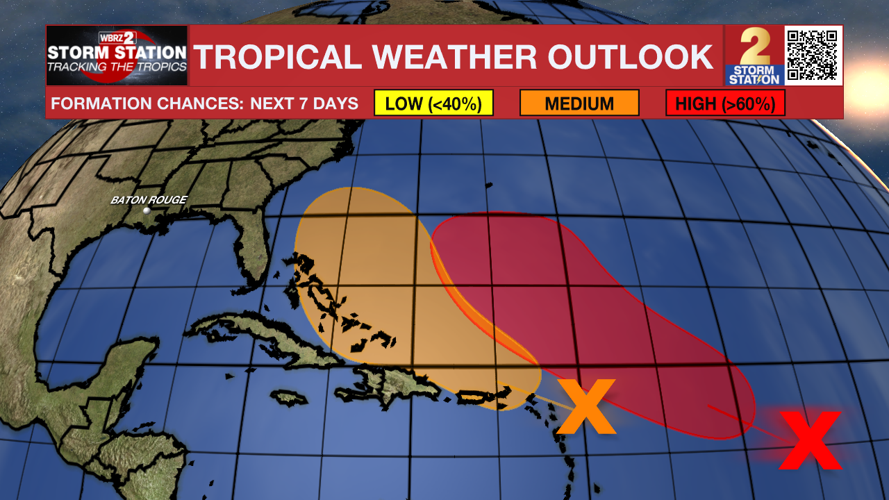
Meanwhile, there are two other areas to monitor:
Central Tropical Atlantic – Shower and thunderstorm activity associated with a tropical wave located about 1000 miles east of the Lesser Antilles is showing signs of organization. Environmental conditions are forecast to
become more favorable for development later today or tonight, and a tropical depression is likely to form on Thursday or Friday while the system moves west-northwestward to northwestward across the western tropical Atlantic.
East of the Windward Islands – A tropical wave located about 100 miles east of the Leeward Islands is producing concentrated, but disorganized, showers and thunderstorms. Environmental conditions appear marginally conducive for some development over the next few days as the wave moves westward to west-northwestward at 15 to 20 mph. By the latter part of this week, the system is expected to slow down and turn
northwestward, and a tropical depression could form late this week when the system is over the southwestern Atlantic Ocean or near the Bahamas. Regardless of development, gusty winds and heavy rainfall are expected to affect portions of the Leeward Islands late tonight and Tuesday, and Puerto Rico and the Virgin Islands late Tuesday and Wednesday.
Get the latest 7-day forecast and real-time weather updates HERE.
Watch live news HERE.
— Balin
The Storm Station is here for you, on every platform. Your weather updates can be found on News 2, wbrz.com, and the WBRZ WX App on your Apple or Android device. Follow WBRZ Weather on Facebook and X for even more weather updates while you are on the go.
More News
