

Latest Weather Blog
Tuesday AM Forecast: Near-record heat today, cold front brings big changes
Tuesday is looking like another very warm day, with temperatures near 90° for the second day in a row. Don't get too used to the heat as an approaching cold front is about to shake things up. Expect the weather to take a sharp turn as we trade the sunshine for multiple waves of rain and a cooling trend to wrap up the week.
Today & Tonight: Once the morning clouds clear out, we’re in for a bright afternoon. Between the extra sun and a high-pressure ridge parked over us, we’re looking at another 90° day, which would put Baton Rouge’s temperature record for the day in jeopardy.
It’s going to feel even stickier than the thermometer suggests; thanks to the humidity, the heat index will likely climb into the mid-90s during the hottest part of the day. Since our bodies aren't quite acclimated to this kind of heat yet, make sure you're staying hydrated and avoiding overexertion outdoors. Don't expect a break once the sun goes down, either, as it’ll stay muggy with lows bottoming out around 73°.

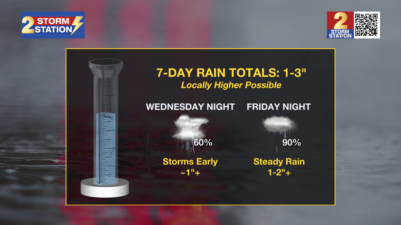
Up Next: The weather pattern is set for a major shake-up starting Wednesday as an incoming cold front brings an end to the heat and ushers in a much wetter stretch. Expect isolated showers and thunderstorms to arrive from the north as early as Wednesday afternoon, with a few potentially turning severe enough to produce large hail and damaging winds. This stormy trend will continue through Thursday as the front pushes through, eventually leading to a more widespread shield of potentially heavy rain Friday night into Saturday due to a developing coastal disturbance.
Trending News
Over the next week, most areas can expect 1–3” of rain, though some spots may see even higher totals. Temperatures will begin a steady decline, starting in the upper 80s on Wednesday before dropping to the low 80s Thursday, the 70s on Friday, and a much cooler mix of 60s and 70s by Saturday. This cooling trend will also be felt at night, with lows dipping into the 50s by the weekend. We should see a slow recovery starting Sunday as the rain clears out, but be sure to keep checking with the Storm Station as the exact timing of the weekend rain comes into better focus.
Get the latest 7-day forecast and real-time weather updates HERE.
Watch live news HERE.
— Balin
The Storm Station is here for you, on every platform. Your weather updates can be found on News 2, wbrz.com, and the WBRZ WX App on your Apple or Android device. Follow WBRZ Weather on Facebook and X for even more weather updates while you are on the go.
More News
