

Latest Weather Blog
Wednesday AM Forecast: Little rain, hot temps through rest of week
We saw some isolated showers and storms Tuesday, but it was nowhere near enough to help with dry grounds. Conditions get drier through the end of the week, with only some spotty showers expected.
Rest of the Week: High pressure will build through the end of the week, bringing down rain coverage to around 10%. Highs will stay in the 90s with humidity noticeable, but once again not to summertime extremes. Lows will bottom out in the upper 60s.
Friday Night Blitz: Expect mostly clear skies with only a few clouds drifting by and no real threat for rain. Kickoff temperatures will be in the upper 80s, easing into the upper 70s as the games move into the second half. Conditions will feel warm but pleasant, especially with a gentle breeze.
LSU Football: Fans heading to LSU on Saturday should prepare for a hot, mostly sunny day with highs topping out in the low 90s. Just like last weekend, tailgaters will want to pack sunscreen, stay hydrated, and find shade when possible. Rain chances are very slim, around 10%, so showers aren’t likely to be an issue. Even as the sun goes down, expect it to stay muggy with temperatures sliding from the 90s into the low 80s by kickoff and into the evening.
Up Next: The overall weather setup won’t shift much this weekend. Both Saturday and Sunday carry a slight chance for a shower, but the majority of outdoor plans and events should stay dry. Afternoon highs will sit in the low 90s, while mornings start off in the upper 60s. Looking ahead to early next week, only a subtle change is expected, with rain chances creeping up into the 20–30% range.
Trending News
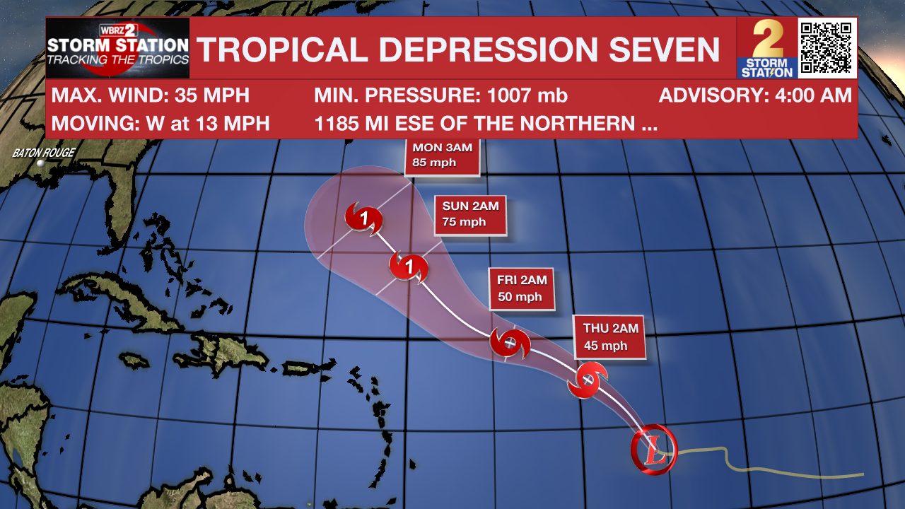
The Tropics: After nearly three weeks without tropical activity, Tropical Depression Seven has recently formed in the southern Atlantic. More info about this system can be found here.
A tropical wave located a couple of hundred miles east-southeast of the Cabo Verde Islands is producing an area of disorganized showers and thunderstorms. Environmental conditions are only marginally conducive, and any development of this system should be slow to occur while it moves westward at 15 to 20 mph across the eastern and central portion of the tropical Atlantic. Regardless of development, this system will likely bring areas of heavy rain across the Cabo Verde Islands later today and Thursday.
Get the latest 7-day forecast and real-time weather updates HERE.
Watch live news HERE.
– Balin
The Storm Station is here for you, on every platform. Your weather updates can be found on News 2, wbrz.com, and the WBRZ WX App on your Apple or Android device. Follow WBRZ Weather on Facebook and X for even more weather updates while you are on the go.
More News
