

Latest Weather Blog
Wednesday AM Forecast: Near-record warmth, AM fog, and a late week storm system
A DENSE FOG ADVISORY is in effect until 10 am. Visibility of one quarter mile or less could make driving conditions hazardous. If driving, slow down, use your low beam headlights, and leave plenty of distance ahead of you.
Wednesday & Thursday: mild with thick morning fog
Friday: stormy
Weekend: much cooler with stubborn clouds

Trending News
Through Thursday: Dense fog will be the main issue both this morning and again early Thursday. With plenty of moisture in the air and overnight lows stuck in the lower 60s, visibility will drop quickly in spots. The fog should be most widespread around the morning commute, so be prepared for abrupt slowdowns along I-10 and I-12. Use low beams and stay attentive. Later in the day, clouds will thin at times, allowing temperatures to surge into the upper 70s and low 80s—close to record territory. By Thursday afternoon, southerly winds will pick up, blowing steadily at 10–20 mph with occasional gust even higher. As even more humid air streams in from the Gulf, scattered showers will pop up, marking the beginning of our next approaching weather system.
Up Next: By Thursday night, an approaching cold front will begin to influence our weather, bringing thicker cloud cover along with increasing winds and more showers. Friday appears to be the most unsettled day, with numerous showers and thunderstorms—around a 80% coverage. While it’s too soon to lock in specific impacts, the overall setup could support a few stronger storms capable of producing gusty winds, especially late Friday. Periods of heavy rain may also create travel issues during the morning or evening commute.
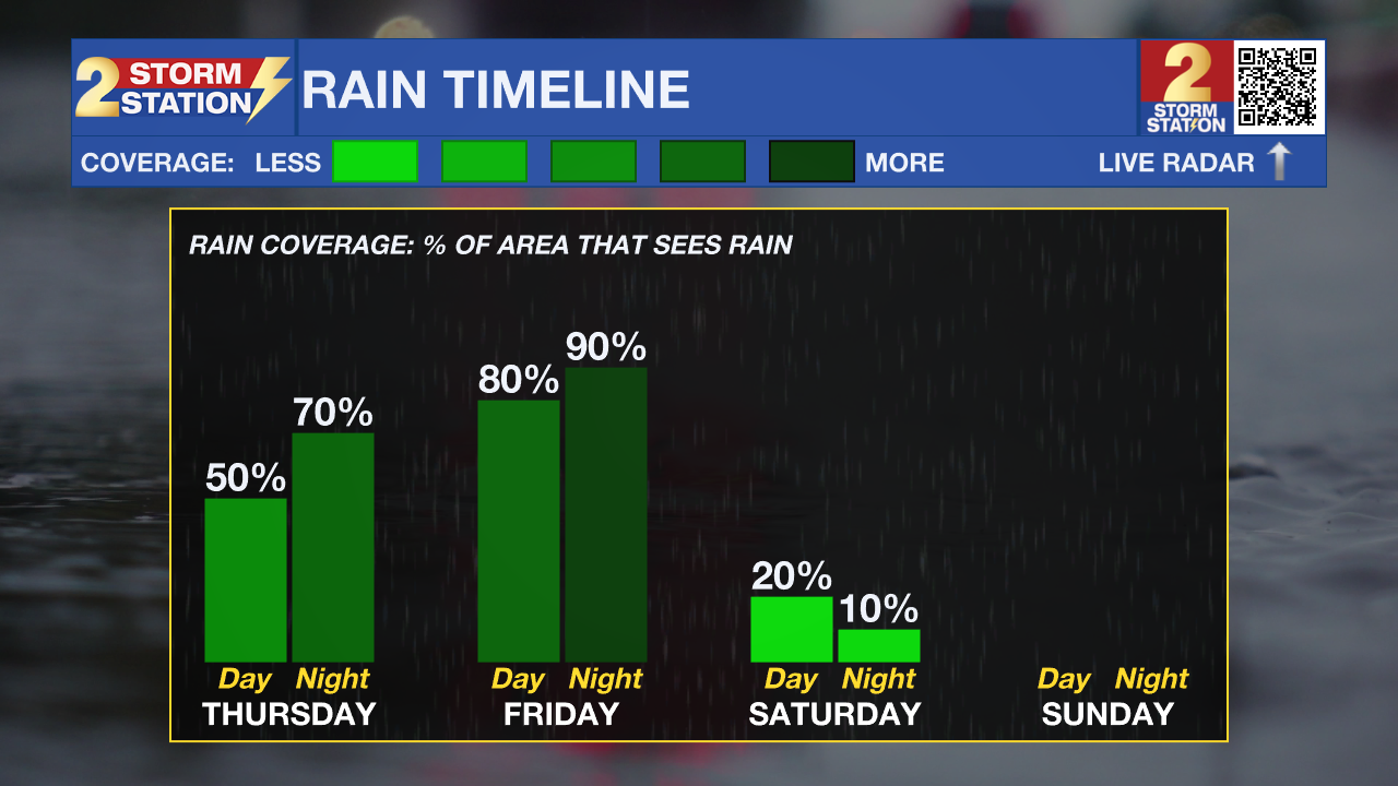
The front will move through the area slowly on Saturday, with temperatures taking a noticeable step down—about 10 to 15 degrees cooler than late in the workweek. Northerly winds behind the front, combined with lingering cloud cover, will make it feel even cooler at times. A few spotty showers may persist through the day as upper-level energy tied to the system gradually exits.
Skies won’t completely clear right away, but the pattern will turn more seasonable. By Sunday and Monday, expect cooler mornings with lows dipping into the low 40s and upper 30s, while afternoon highs settle into the upper 50s.
Get the latest 7-day forecast and real-time weather updates HERE.
Watch live news HERE.
– Balin
The Storm Station is here for you, on every platform. Your weather updates can be found on News 2, wbrz.com, and the WBRZ WX App on your Apple or Android device. Follow WBRZ Weather on Facebook and X for even more weather updates while you are on the go.
More News
