

Latest Weather Blog
Wednesday PM Forecast: warming trend continues ahead of strong weekend storms
A warming trend will continue through the end of the week ahead of the Capital Area's next impact. Another round of thunderstorms, as well as severe weather, is possible heading into the weekend.
Tonight & Tomorrow: A mostly clear evening sky will become partly cloudy overnight as a minor disturbance passes nearby. A stray shower or sprinkle is possible overnight and early Thursday. They will be few and far between; most will only notice a few extra passing clouds. Low temperatures will trend warmer as a result, only dipping into the low-60s. Thursday will start off with partly sunny skies and end with sunshine. Expect another uptick in high temperatures, climbing into the mid-80s.
Up Next: By Friday, a stronger disturbance will move into the Midwest, with the local area finding increasing south winds up to 25 mph, more cloud cover, and a slightly better chance for a spotty shower or thunderstorm. Still, do not expect any major impact to outdoor activities; the real action arrives over the weekend.
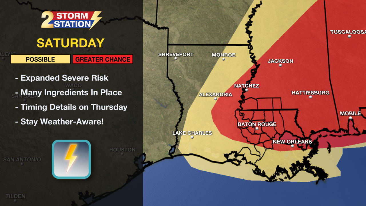
Saturday: A potent storm system will approach the Capital Area in the form of a cold front. This will bring more widespread rain and thunderstorms and, perhaps more notably, the possibility of severe weather. Storm energy and winds will quickly increase through the morning and overlap with one another. If any storms can tap into this energized state, they would be capable of all severe hazards such as wind, hail, and isolated tornadoes. Despite favorable ingredients being in place areawide, areas along and northeast of the I-10 corridor may serve as a hotbed for severe weather—especially into Mississippi and Alabama. The responsible storm system will move onshore in the western U.S. by Wednesday night, allowing the upper-air network to sample the storm holistically. This will result in a more refined forecast beginning Thursday. The Storm Station expects hourly timing to become more clear around that time.
Trending News
Beyond: After the storms move out, Sunday and Monday will be much calmer. Highs will ease back into the upper 70s, with lows dipping into the upper 40s to low 50s. The weather will be much calmer for the recently rescheduled Wearin’ of the Green on Sunday. Mostly sunny skies will dominate for the second half of the weekend and to start the new workweek.
Get the latest 7-day forecast and real-time weather updates HERE.
Watch live news HERE.
– Meteorologist Malcolm Byron
The Storm Station is here for you, on every platform. Your weather updates can be found on News 2, wbrz.com, and the WBRZ WX App on your Apple or Android device. Follow WBRZ Weather on Facebook and X for even more weather updates while you are on the go.
More News
