Friday evening video forecast
Related Story
Most locations have picked up over two inches of rain since Thursday thereby knocking October 2024 out as one of the top ten driest (ending ranked 48/133). The wet weather will subside as we move into a warm start to November.
Tonight & Tomorrow: Lingering showers and thunderstorms will taper through the evening hours. Beneath mainly cloudy skies, low temperatures will barely slide into the upper 60s overnight. Saturday will feature gradually clearing skies with some sun expected during the afternoon. A sticky fall feel will continue with highs in the mid 80s.

Up Next: Sunday could begin with patchy fog. Be alert to reduced visibility if driving to church services or elsewhere near daybreak. The afternoon will be primarily dry, warm and unseasonably humid with highs in the upper 80s. Not much change is expected for the new workweek and first full week of November. A number of record highs, and especially record warm lows will be in danger with highs near 90 and lows near 70. On Tuesday, a weakening front over Texas could help to generate another round of showers and thunderstorms across the central Gulf Coast. However, the front will not make it through the Capital Area and temperatures will remain status quo.
Get the latest 7-day forecast and real time weather updates HERE.
Watch live news HERE.
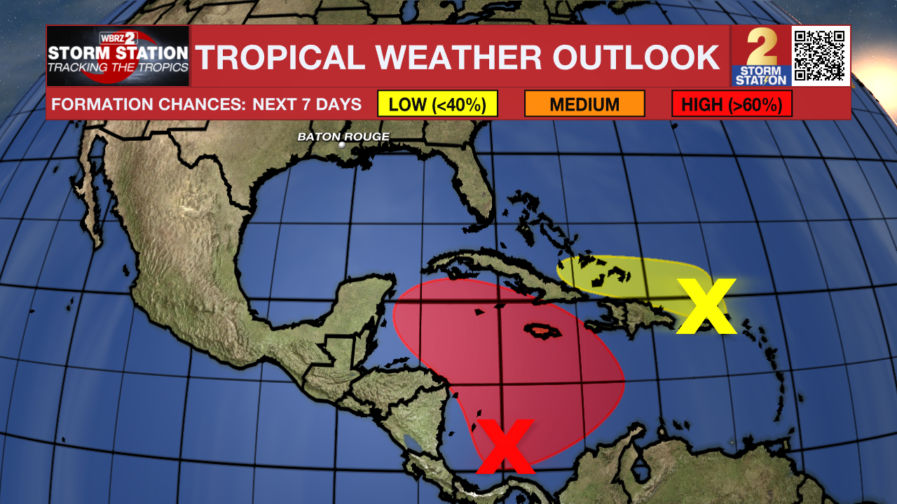
The Tropics: A broad area of low pressure is likely to develop over the southwestern Caribbean Sea during the next day or so. Gradual development is possible thereafter, and a tropical depression is likely to form late this weekend or early next week while the system drifts generally northward or northwestward over the central or western Caribbean Sea. Regardless of development, locally heavy rains are possible over portions of the adjacent land areas of the western Caribbean.

A trough of low pressure located near Puerto Rico is producing a large area of showers and thunderstorms over portions of the Greater Antilles and the adjacent waters of the Atlantic and the northeastern Caribbean. Slow development of this system is possible during the next few days as it moves west-northwestward near the Greater Antilles. After that time, this system is expected to be absorbed into the low pressure area over the Caribbean. Regardless of development, locally heavy rains are possible during the next several days from the northern Leeward Islands westward across Puerto Rico and Hispaniola to eastern Cuba and the southeastern Bahamas.
A low pressure system located a few hundred miles west of the Azores has been producing increased convection near its center over the past few hours. Earlier satellite derived wind data depicted winds to storm-force mainly to the south of the center. Environmental conditions appear favorable for some additional development and the system could become a subtropical or tropical storm as it moves generally eastward during the next few days.
– Josh
The Storm Station is here for you, on every platform. Your weather updates can be found on News 2, wbrz.com, and the WBRZ WX App on your Apple or Android device. Follow WBRZ Weather on Facebook and Twitter for even more weather updates while you are on the go.


