

Latest Weather Blog
Friday morning video forecast
Related Story
Temperatures this morning are in the low 60s and upper 50s for much of the area! Humidity will stay low all weekend long, leading to some great football weather.
Today & Tonight: After the cool morning start, highs will reach into the mid-80s under mostly sunny skies. Dry air will lead to no humidity, and no chance of rain. This will be the perfect weather for outdoor activities, including the Blitz! Overnight, expect mainly clear skies with lows near 60 degrees.
Friday Night Blitz: A near-perfect night is setting up for high school football! Under clear skies, temperatures will be dropping through the 70s during the games. Expect kickoff temperatures in the upper 70s, falling into the low 70s by the final whistle.
The Weekend: Get ready for a great weekend of weather! Dry air will stay in place, meaning humidity will not be a factor. Highs will top out in the mid-80s, with lows near 60 degrees. Some locations could even drop into the upper 50s for the first time this fall. Football weather will be in full force!
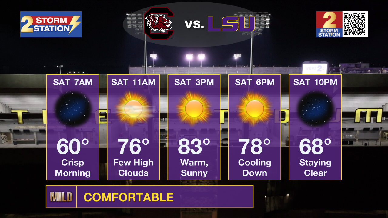
LSU Homecoming: Saturday’s tailgating weather will kick off with a refreshing feel in the low 60s before warming into the mid-80s. By the 6:45 p.m. kickoff, conditions will be just about perfect — around the upper 70s — then gradually dipping into the upper 60s as the game winds down.
Southern on the Road: The Jags travel to Daytona Beach, Florida, to take on Bethune-Cookman at 2:00 p.m. on Saturday. The weather will be a factor as winds will be sustained over 20mph and gust over 30mph during the game. A few passing showers are even possible. Temperatures will be in the upper 70s during most of the game.
Up Next: Heading into next week, temperatures will start trending upward again. Afternoon highs will rise to around 87° Monday, 88° Tuesday, and near 89° by Wednesday. Nights will get a bit milder too, with lows easing up to about 64° by Thursday morning. It won’t feel quite as cool as the weekend, but the dry stretch continues — plenty of sunshine and no rain in sight.

The Tropics: Tropical Storm Jerry remains disorganized, with most storms displaced to the south and east of its center due to wind shear. Aircraft and satellite data show the center may be stretched out and pressure rising, meaning it’s weakening slightly. Winds are near 50 mph. Though the center is north of the Leeward Islands, heavy rain continues there, bringing a risk of flash flooding. Jerry is moving northwest and will turn north tonight, then northeast early next week while staying well southeast of Bermuda. With continued wind shear, little to no strengthening is expected, and Jerry is now unlikely to become a hurricane.
Get the latest 7-day forecast and real-time weather updates HERE.
Watch live news HERE.
– Balin
The Storm Station is here for you, on every platform. Your weather updates can be found on News 2, wbrz.com, and the WBRZ WX App on your Apple or Android device. Follow WBRZ Weather on Facebook and X for even more weather updates while you are on the go.
News
