

Latest Weather Blog
Tuesday evening video forecast
Related Story
There are two big weather impacts yet to come this week, including the second freeze of the cool season and another, more soaking rain event.
Wednesday: morning freeze, mild afternoon
Thursday & Friday: challenging commutes with periods of rain, heavy at times
Weekend: trending drier, not as chilly
Tonight & Tomorrow: Our coldest morning of the week is expected on Wednesday. Mainly clear skies and light winds will work with an already low starting point of Tuesday highs in the 40s, for lows to get into the 30s. A light freeze is expected there for a few hours before sunrise, especially along and north of I-12. Bring pets inside, and cover or move sensitive vegetation. Wednesday afternoon will offer some moderation, as highs jump into the low 60s partly sunny skies.

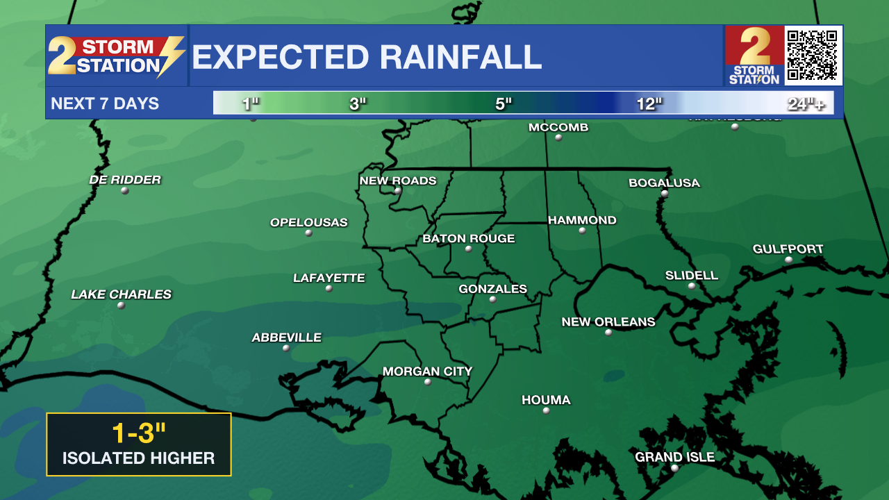
Up Next: By Wednesday night, another strong storm will take shape in the western Gulf. Expect widespread rain and even some thunderstorms to begin overnight, continue Thursday morning, and then last at least in an off and on nature through Friday. Total rainfall over those two days could be in the 1 to 3-inch range for the Baton Rouge area. However, there's a possibility that some localized areas could see higher amounts, possibly reaching 4 inches on Thursday. While the rain is expected to fall over a longer period, which should prevent major flash flooding, keep a close eye on the weather for alerts with the Storm Station Weather App. Downpours could still cause street flooding or ponding on roadways, so prepare for some travel delays, drive carefully, and never drive through flooded areas. Through the duration of the rain event, temperatures will not move very much, with nighttime lows in the upper 40s and daytime highs in the mid-50s. It will feel damp and cool.
Rain will begin to taper in time for the weekend. Isolated showers remain a possibility on Saturday, but certainly will not cause outdoor events to be canceled; a lot of spots are likely to stay dry. Mostly cloudy skies will keep temperatures cool with highs in the upper 50s. A warming trend will continue on Sunday with a little bit more sun and highs in the mid-60s. The new week will continue that pattern.
Get the latest 7-day forecast and real-time weather updates HERE.
Watch live news HERE.
– Josh
The Storm Station is here for you, on every platform. Your weather updates can be found on News 2, wbrz.com, and the WBRZ WX App on your Apple or Android device. Follow WBRZ Weather on Facebook and X for even more weather updates while you are on the go.
News
