

Latest Weather Blog
Wednesday Midday Video Forecast
Related Story
The final days leading up to the Fall Equinox on Sunday will definitely hold a summertime feel. Expect mild and muggy mornings followed by hot and humid afternoons.
Today & Tonight: Fog may become an issue during the early morning commute Wednesday as temperatures will fall very close to the dew point temperature, in the lower 70s, under clear skies and calm winds; the ideal set up for fog development. It's advised to use extra caution from 5-9am as patchy areas of dense fog could create very limited visibility on the roadways.
Once the sun rises and temperatures begin to warm, we will be left with party sunny skies and only a spotty shower or two around this afternoon. Temperatures Wednesday will near 91° in Baton Rouge. Humidity remains, meaning it will feel a bit warmer than the actual temperatures displays and winds will remain fairly light.
Wednesday night, temperatures will fall back to the lower-70's under mostly clear skies, again raising the possibility of fog formation early Thursday morning.
Up Next: Rain chances become slim to none on Thursday and through the weekend as upper-level ridging takes over. Warmer air aloft will keep skies mainly sunny each day and allow temperature to warm into the low to middle 90s, a few degrees above average for this time of year. Feels-like temperatures will likely push 100 degrees each afternoon over the weekend. Saturday afternoon in Tiger Stadium looks to be a toasty one as LSU hosts UCLA. Stay tuned to the Storm Station for the LSU Kickoff Weather Index later this week.
Hot conditions will continue on Sunday, a.k.a. the first official day of Fall, and into next week. Although it won't feel like Autumn outside, a true sign that the new season is upon us will be spotted each evening when the sun sets before 7:00pm.
Get the latest 7-day forecast and real time weather updates HERE.
Watch live news HERE.
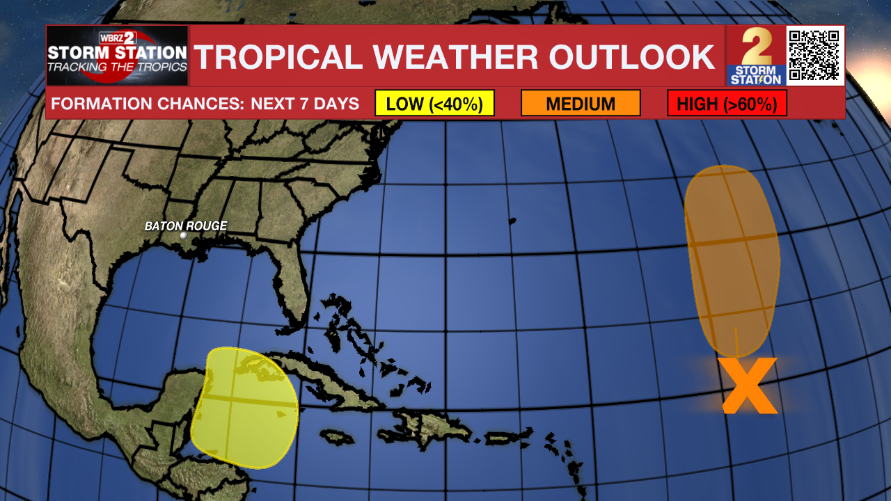
The Tropics: Disorganized showers and thunderstorms over the central tropical Atlantic are associated with the remnants of Gordon. This disturbance is forecast to interact with a non-tropical low to its north while moving north-northeastward at 5 to 10 mph during the next couple of days. Environmental conditions could become more conducive for redevelopment later this week, and a tropical depression or storm could form by this weekend while the system moves slowly northward over the central subtropical Atlantic.
The National Hurricane Center has highlighted an area in the northwestern Caribbean Sea that could form a broad area of low pressure this weekend . Thereafter, some slow development of this system is possible through early next week while it moves slowly to the north or northwest. As of now, this system poses no direct threat to Louisiana.
– Emma Kate C.
The Storm Station is here for you, on every platform. Your weather updates can be found on News 2, wbrz.com, and the WBRZ WX App on your Apple or Android device. Follow WBRZ Weather on Facebook and Twitter for even more weather updates while you are on the go.
News
