

Latest Weather Blog
FLOOD WATCH: tropical moisture brings threat of heavy rain to Capital Area
The rest of the week will bring rounds of soaking rain and thunderstorms thanks to abundant tropical moisture, a stalled front, and a disturbance moving into the Gulf. This combination of features will lead to 3-6 inches of additional rainfall, with isolated amounts twice that high that will result in flash flooding.
Tropical Storm Watches have been issued along the central Gulf Coast, extending from the east Texas coastline to St. Mary Parish, as a brief tropical storm may develop on Wednesday. Through Thursday, there may be minor coastal flooding and some wind gusts over 30mph and the coast, while the primary impact remains heavy rain for inland areas. The National Hurricane Center has started issuing forecasts for Potential Tropical Cyclone One. Review the reason behind the relatively new potential “tropical cyclone terminology” HERE.
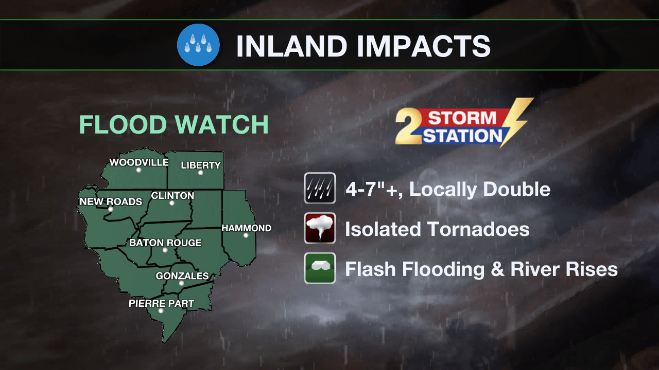
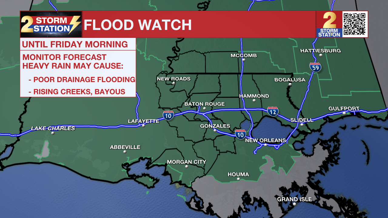
A FLOOD WATCH remains in effect for the entire Capital Region through Friday morning. A FLASH FLOOD WATCH means conditions may develop that lead to flash flooding. Flash flooding is a very dangerous situation. Be on the lookout for threatening weather conditions and listen for later statements and possible warnings. For more on flooding safety, CLICK HERE.
A FLOOD WATCH remains in effect for the entire Capital Region through Friday morning. A FLASH FLOOD WATCH means conditions may develop that lead to flash flooding. Flash flooding is a very dangerous situation. Be on the lookout for threatening weather conditions and listen for later statements and possible warnings. For more on flooding safety, CLICK HERE.
Trending News
Tonight & Tomorrow: While the initial widespread wave of rain and thunderstorms will lose some steam after sunset due to the loss of daytime heat, a stalled front sitting right over the Capital Area will keep showers and a few thunderstorms in play overnight. Just like the daytime hours, if storms stack up and move over the exact same neighborhoods repeatedly, a process called training, there could easily be quick bursts of 2 to 4 inches of rain in small spots.
On Wednesday, the approaching tropical system will actually squeeze down cloud cover a bit on its outer edges, granting a few breaks of sunshine. The breaks of sunshine and dry time will be only that, as scattered showers and thunderstorms will remain possible throughout the day. While we may see fewer total storms on Wednesday, the ones that do break out will be capable of dumping heavy rain very quickly.

Use the slider to advance through the next 24 hours of Futurecast
Up Next: By early Thursday, the Capital Area will be very vulnerable to flooding after multiple days of downpours. Remnants of the tropical disturbance will move across Louisiana and Mississippi, putting the local area on the eastern, more active side of the system. Heavy, tropical rain bands will bring widespread amounts of 3-6 inches of rain with “streaks” of 10-20 inches possible where bands repeat. If those amounts occur in our cities rather than open marsh or swamp land, it will trigger significant poor drainage and river flooding. In addition to the heavy rain, circulation associated with the tropical disturbance could also lead to an isolated, brief tornado.
On Friday, the tropical system will finally pull away to the east. Scattered showers and thunderstorms will develop due to lingering tropical moisture. Expect a slow, gradual lowering of daily rain coverage with the pattern moving back toward daytime warming pop-up thunderstorms over the weekend. Humidity will stay in place and highs will return to the 90s.

Get the latest 7-day forecast and real-time weather updates HERE.
Watch live news HERE.
The Tropics: As of 3pm Tuesday, Potential Tropical Cyclone One, was about 345 miles southwest of Lake Charles with maximum sustained winds of 30 mph. The system was moving northeast at 6 mph and expected to speed up over the next couple of days, moving offshore Tuesday night before tracking parallel to the upper Texas coast on Wednesday. There is a high chance it officially strengthens into a tropical storm Wednesday morning before making landfall in extreme eastern Texas or southwestern Louisiana late Wednesday or early Thursday.

— The Storm Station Meteorologists
The Storm Station is here for you, on every platform. Your weather updates can be found on News 2, wbrz.com, and the WBRZ WX App on your Apple or Android device. Follow WBRZ Weather on Facebook and X for even more weather updates while you are on the go.
More News
