

Latest Weather Blog
UPDATE: Flood Watch posted for much of the Capital Area ahead of heavy rain threat
The National Weather Service has issued a FLOOD WATCH for East Baton Rouge, West Baton Rouge, Ascension, Iberville, East Feliciana, Livingston, Pointe Coupee, St. Helena, Tangipahoa, and West Feliciana Parishes, as well as Amite and Wilkinson Counties from 7 a.m. Monday until 7 a.m. Wednesday.
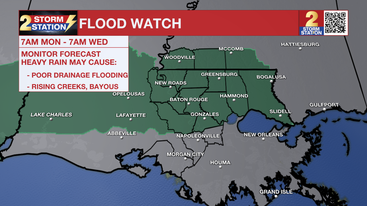
A FLASH FLOOD WATCH means conditions may develop that lead to flash flooding. Flash flooding is a very dangerous situation. Be on the lookout for threatening weather conditions and listen for later statements and possible warnings. For more on flooding safety, CLICK HERE.
A cold front, tropical moisture, and a separate tropical disturbance will work together to kick off multiple rounds of storms over the next week. While it won’t be a continuous washout, a few distinct rounds of heavy rain could trigger occasional street and poor-drainage flooding. All told, 3-6” of rain looks likely over the next week, with localized areas seeing on the order of 6-8”+. There is a chance that Flood Watches may need to be extended later in time.
Tonight & Tomorrow: Clouds and storm chances will increase Sunday night, kicking off an extended period of stormier weather. While isolated evening thunderstorms should taper off after sunset, a nearby frontal system tapping into tropical moisture will likely trigger a fresh round of storms early Monday morning. These heavy downpours could impact the morning commute, so watch for slick roads and allow for extra travel time. Overnight lows will stay warm in the mid to upper-70s.
Trending News

Use the slider to advance through the next 24 hours of Futurecast
Early showers and thunderstorms appear to taper into the afternoon, resulting in more dry time. However, isolated activity remains possible during the second half of the day, particularly north of I-10. Clouds will hold temperatures down, keeping highs limited to the mid-to-upper 80s.
Up Next: Tuesday looks much busier as widespread thunderstorms overtake southern Louisiana. Locally heavy rainfall could trigger isolated street and poor-drainage flooding at times. The rain will bring even more heat relief, keeping afternoon highs tucked away in the upper 70s and lower 80s.
A tropical disturbance will move through in the Wednesday/Thursday timeframe, bringing another wave of heavy rain and storms. The National Hurricane Center notes a low chance of development with this system, but regardless of formation, the local impact would remain the same. Following rain from early-week storms, midweek tropical downpours could be more problematic from a flash flooding standpoint. Local river levels will need to be monitored as well, though there are no immediate concerns as of now. Rain coverages will steadily step down Friday through Sunday, allowing highs to return to the 90s next weekend.


Get the latest 7-day forecast and real-time weather updates HERE.
Watch live news HERE.
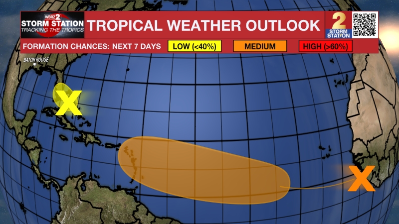
The Tropics: A disturbance over northeastern Mexico remains disorganized as of Sunday evening. While it will stay over land for the next day or so, the system is expected to reemerge over the northwestern Gulf late Tuesday or Wednesday. Once over open water, it has a roughly 30% chance of tropical development before moving inland by Thursday. Regardless of formation, heavy rainfall and flash flooding will be possible across the central Gulf Coast, including the Capital Area. The first name up on the list of names for 2026 is Arthur.
— Meteorologist Malcolm Byron
The Storm Station is here for you, on every platform. Your weather updates can be found on News 2, wbrz.com, and the WBRZ WX App on your Apple or Android device. Follow WBRZ Weather on Facebook and X for even more weather updates while you are on the go.
More News
