

Latest Weather Blog
Friday AM Forecast: Sizzlin' weekend ahead
Fall may officially begin on Sunday but Summer is not letting go just yet. Hot and dry conditions will persist all weekend, creating not-so-comfortable conditions for those with outdoor activities. Keep heat safety in mind if you are heading into Tiger Stadium on Saturday.
Today & Tonight: Mostly sunny skies and temperatures in the low to middle 70's will kick off your Friday morning. Once the sun rises during the 7:00am hour, a few areas may see fog develop, though most will see clear skies. Full sunshine will help temperatures warm quickly, near 90 degrees by lunchtime and into the middle-90's by late afternoon. With plenty of humidity around this afternoon, temperatures will likely feel above 100° at times. No rain showers will aid in cooling anyone off today so make sure to take breaks in the air conditioning and stay hydrated when spending time outdoors.
Overnight, mainly clear skies will remain, allowing temperature to return to the lower-70's by sunrise Saturday morning.
Up Next: The summertime sizzle will continue all weekend long with muggy mornings in the 70's turning to very hot and humid afternoons in the mid-90's. These above average temperatures also come with an added punch of humidity which will make afternoon feels-like temperatures +100°. According to the LSU Kickoff Weather Index, a feels-like temperature +100 degrees at game time will make this one of the top three hottest on record in Tiger Stadium. The last game this hot came against Tennessee in 2005 as the teams kicked off to a heat index of 103 degrees. Stay hydrated and stay cool when participating in game day activities this weekend, Tiger fans!
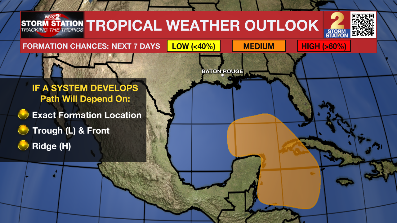
Into next week, there are a number of factors that will play into the forecast including a weak front approaching from the northwest and the possibility of a tropical system in the southeastern Gulf of Mexico. Any added impacts such as rain or a cold front passage will likely not be in play until Wednesday or Thursday. Check back in with the Storm Station over the weekend as we get a better idea of next week's weather pattern.
Trending News
Get the latest 7-day forecast and real time weather updates HERE.
Watch live news HERE.
The Tropics: A broad area of low pressure could form by early next week over the northwestern Caribbean Sea. Thereafter, gradual development of this system is possible, and a tropical depression could form as the system moves slowly to the north or northwest over the northwestern Caribbean Sea and into the southern Gulf of Mexico through the middle part of next week.
An area of showers and thunderstorms located over the central subtropical Atlantic is associated with the remnants of Gordon. Some development of this system is possible while it moves northward or north-northeastward over the next few days.
An area of low pressure located about 750 miles southeast of Bermuda is producing disorganized showers and thunderstorms. Environmental conditions appear only marginally conducive, but some development of this system is possible while it meanders over the open waters of the central or western Subtropical Atlantic though early next week.
– Emma Kate C.
The Storm Station is here for you, on every platform. Your weather updates can be found on News 2, wbrz.com, and the WBRZ WX App on your Apple or Android device. Follow WBRZ Weather on Facebook and Twitter for even more weather updates while you are on the go.
More News
