

Latest Weather Blog
Monday PM Forecast: heat index peaks tomorrow before midweek storms
Heat will continue to grip the Baton Rouge Area through the beginning of the workweek as afternoon feels-like temperatures soar over 105 degrees. Cooling rain relief will arrive midweek but may also stick around to complicate outdoor Fourth of July plans.
Heat Peak: Tuesday with feels-like temperatures between 105 – 110 degrees
Storms Return: Wednesday onward may have bouts of cooling downpours, gusty wind
Holiday Weekend Outlook: afternoon storms briefly disrupt barbecues and fireworks

Trending News
Tonight & Tomorrow: A ridge of high pressure in the atmosphere will maintain its grip on the region into the new week. The ridge overhead results in warm, sinking air that squashes most thunderstorm development and causes warmer temperatures.
Tonight will remain warm and sticky, with overnight lows hovering in the upper 70s. Tomorrow, the heat machine turns up a little higher. Afternoon temperatures will easily bake into the mid-to-upper 90s. When you mix that actual air temperature with increasing humidity, the "feels-like" heat index will spike between 105 and 110 degrees. However, changes will begin at this point. The ridge will shift northward toward the Midwest. As it moves, it will pull a wave of tropical moisture from east to west across the Gulf Coast, possibly igniting a late-day shower or thunderstorm, especially east of Baton Rouge.

Use the slider to advance through the next 24 hours of Futurecast
Up Next: The wave of tropical moisture will plow through the Metro Area fairly quickly on Wednesday. It will knock down temperatures and create a batch of heavy thunderstorms. While the quick-moving nature of the system will limit the threat of prolonged flooding, a few areas may experience brief street flooding and gusty winds.
Once that system exits to the west, expect a return to the standard summer weather pattern for Thursday and Friday. Plenty of humidity will linger, bringing a daily dose of afternoon pop-up showers and thunderstorms.
Yet another weak wave of energy will move into the region for the Fourth of July Weekend. As of now, it doesn’t look to be a “plan-canceller,” but have an indoor break option from brief afternoon downpours and lightning.
Get the latest 7-day forecast and real-time weather updates HERE.
Watch live news HERE.
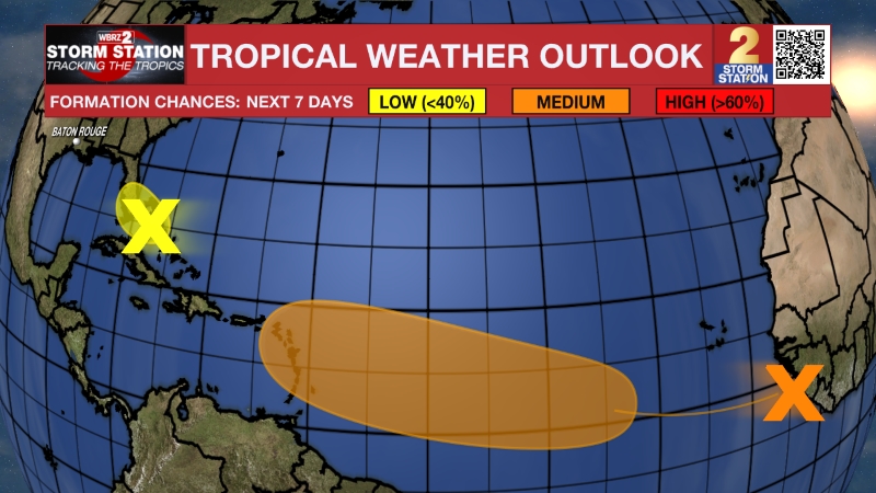
The Tropics: A broad low-pressure area has been causing unorganized showers and thunderstorms near the southeastern United States. While the system drifts slowly westward over the subsequent couple of days, gradual development remains possible over the next day or two. However, environmental conditions will become less favorable for further organization by the end of the week. Consequently, the system has a low 10 percent chance through the next seven days.
– Josh
The Storm Station is here for you, on every platform. Your weather updates can be found on News 2, wbrz.com, and the WBRZ WX App on your Apple or Android device. Follow WBRZ Weather on Facebook and X for even more weather updates while you are on the go.
More News
