

Latest Weather Blog
Saturday AM Forecast: Finally trending in a drier direction, heat cranks up
After an active week of weather, the forecast in finally trending in a drier direction. The result of less rain means the heat will take its place!
Here is a breakdown of what to expect:
- The Weekend: very warm and muggy, rain becomes more spotty
- Next Week: remaining warm and mainly dry, storm chances return near Thursday
The Weekend: An upper-level ridge of high pressure building this weekend will effectively shut down the chance for showers and thunderstorms. A stray sprinkle is possible, but nothing much more significant than that is expected. Given less rain, and even less cloud cover, temperatures will begin to increase to near-record levels. Highs will be in the upper 80s on Saturday, and increase to near 90 degrees on Sunday. This could possibly tie or break a record high. Morning time lows will be in the mid 60s. Also in morning, fog will be a possibility.
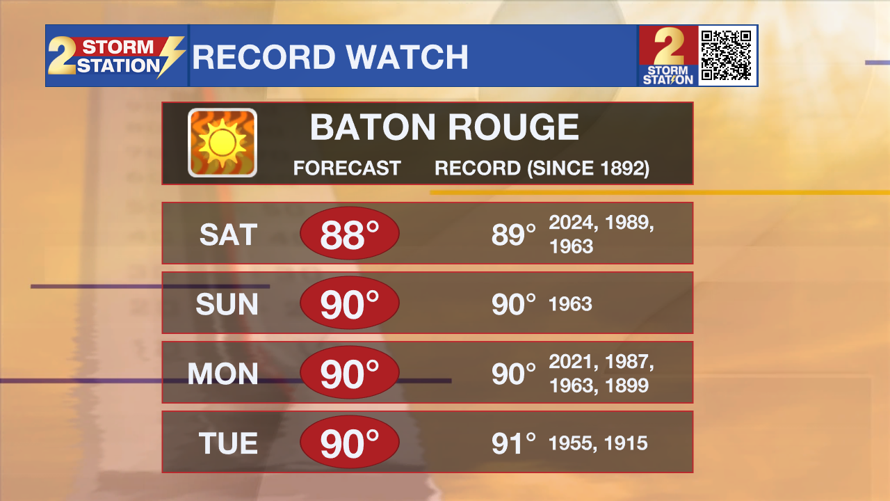
Up Next: The heat and dry conditions will continue into early next week. A few more high temperature records will be threatened. Continue staying hydrated as everyone collectively adjusts to the warmer, steamier conditions. Conditions will begin to change by mid-week ahead of our next storm system. Expect an increase in clouds, followed by rain chances returning late week.
Trending News
River Flooding: The National Weather Service has issued a RIVER FLOOD WARNING for the Mississippi River at Red River Landing, Baton Rouge, Donaldsonville, and Reserve, as well as the Atchafalaya River at Morgan City until further notice.
• At Red River Landing, flood stage is at 48 feet. Moderate flooding is already occurring. A crest of 59.5 feet is expected around April 30. At this level, the east bank levee will be topped, and the prison farmland between the two levees will be inundated. Angola Landing will be under water, closing the ferry there. All river islands along the reach from Red River Landing to Baton Rouge will remain inundated with recreational camps and river bottom farmland under water. This gauge will fall below flood stage around May 14.
• At Baton Rouge, flood stage is 35 feet. Major flood stage has been reached, with a crest at 42 feet expected on May 1. Around these levels, the grounds of the older part of Louisiana State University's campus become soggy. This includes the area around the Veterinary Medicine building, the Veterinary Medicine Annex, and Alex Box Stadium. Levees protect the city of Baton Rouge and the main LSU campus at this level. Caution is urged when walking near riverbanks. This gauge will fall below flood stage around May 12.

• At Donaldsonville, the flood stage is at 27 feet. Moderate flooding will begin shortly. Moderate flooding with a crest of 31 feet is expected around May 1. Around these levels, navigation becomes difficult for smaller river craft. Safety precautions for river traffic are urged. After cresting, the river will fall below flood stage around May 11.
• At Reserve, flood stage is at 22 feet. Minor flooding is already occurring. A crest of 23.5 feet is expected around May 1. Around these levels, slow-bell procedures will be enacted for river transportation. After cresting, the river will fall below flood stage around May 9.
• At Morgan City, flood stage of 6 feet will be reached by Saturday. Moderate flooding with a crest of 7 feet is forecast on May 3. At 7 feet, buildings at the foot of Ann Street on the riverside of the flood wall will flood as water overtops the Rio Oil Company dock. Buildings on the riverside of the Berwick floodwall will flood. River traffic restrictions will be strictly enforced. In addition, backwater flooding could potentially impact portions of areas around Lake Palourde and Stephensville.
Get the latest 7-day forecast and real-time weather updates HERE.
Watch live news HERE.
-- Balin
The Storm Station is here for you, on every platform. Your weather updates can be found on News 2, wbrz.com, and the WBRZ WX App on your Apple or Android device. Follow WBRZ Weather on Facebook and X for even more weather updates while you are on the go.
More News
