Snow has arrived! Hazardous roadway conditions likely to follow
A *WINTER STORM WARNING* will remain in effect across all of south Louisiana until 12 a.m. Wednesday. Heavy snowfall across most of south Louisiana will occur Tuesday as an Arctic Blast settles into the area. This system will generally move west to east across the Gulf of Mexico sending a plume of moisture across the frigid air mass.
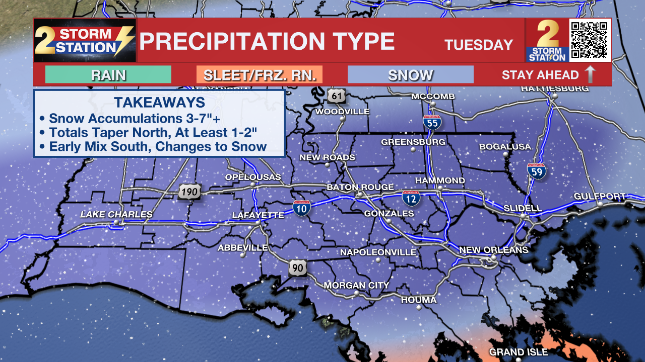
Snow/Ice Accumulations: At this point, measurable snow is almost a certainty across the Capital Area. Many could see snow accumulations on the order of 3 to 7 inches. If snow totals end up in this range, that would rank as one of the Top 5 snowfalls for Baton Rouge. As of Monday afternoon, much of the guidance depicts a notable shift south in where the heaviest axis of snow sets up. That puts 3-7"+ of snow in play for areas south of I-10/12. Such a shift would also push the northern cutoff for snow closer to Amite/Wilkinson Counties. That could result in a fast ramp down in snow totals across north of Baton Rouge, into Mississippi. This trend will need to be closely monitored for further adjustments.

Some areas, especially south of I-10/12, might observe a brief period of sleet around the onset of precipitation. But that will be short-lived as a full transition to snow will eventually occur.
Just like with rainfall, there may be isolated pockets with higher snow totals. Accumulations are still subject to change.
Winter Storm Timing: Light snow should begin as early as the pre-dawn hours on Tuesday. Coverage and intensity of snowfall will increase through the morning. Snow will taper late in the day and end by evening.
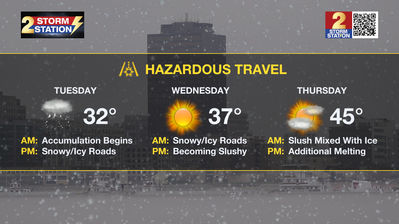
Travel Impacts: Snow and ice could result in a multi-day travel headache. Roads, especially bridges and overpasses, will likely become treacherous. Plan on slick roads and hazardous travel beginning Tuesday morning. Consider delaying all travel. But if absolutely necessary, drive with extreme caution. A winter storm kit including items such as tire chains, booster cables, flashlights, shovels, blankets, and extra clothing is a good idea. Also take water, a first aid kit, and anything else that would help you survive if you become stranded. Snow and ice will remain on roadways at least through Wednesday morning. Although partial melting might take place on Wednesday, a refreeze is expected Wednesday night. This could lead to an icy slush on Thursday morning.
Trending News

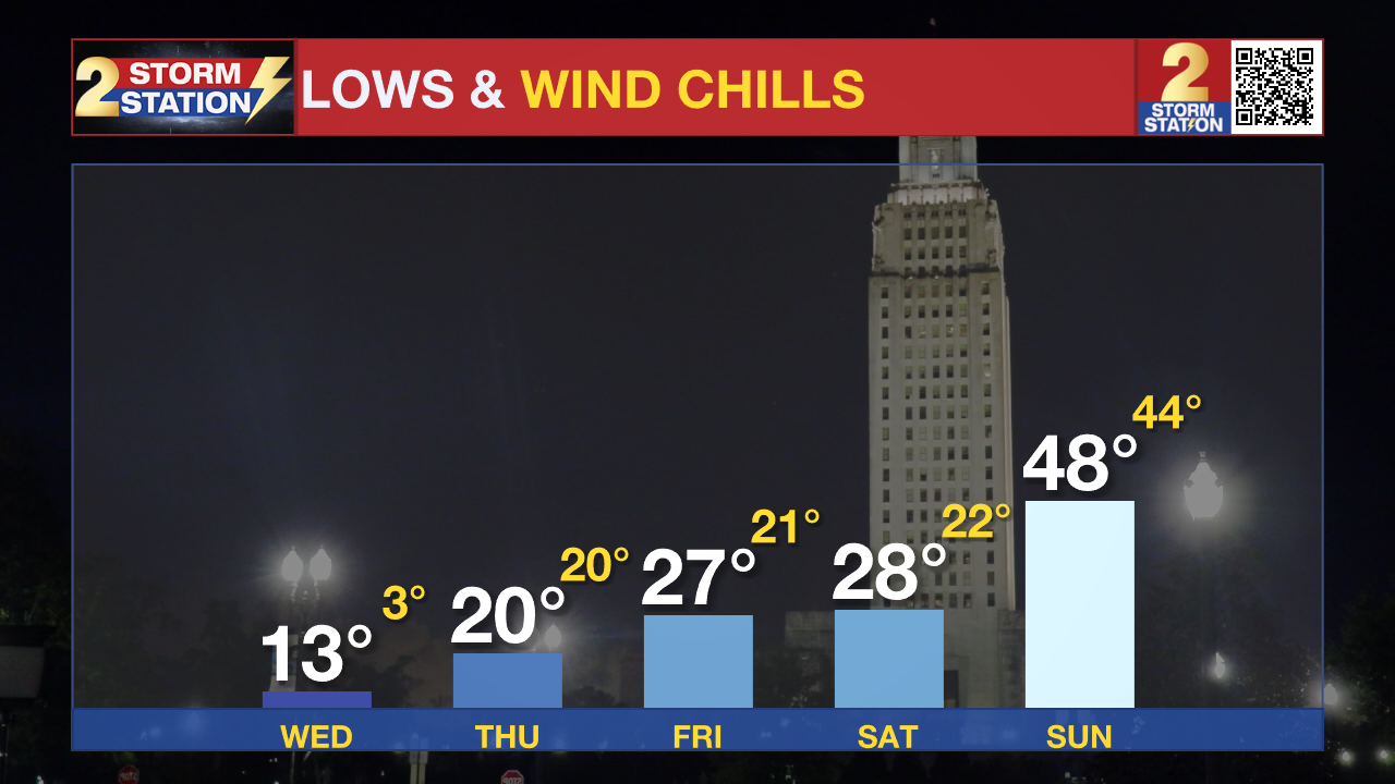
Dangerous Cold: Multiple hard freezes are expected in the following days with lows in the teens and 20s. At these temperatures, exposed, outdoor pipes could rupture if not wrapped. In addition to that, a slow drip of inside faucets overnight and leaving cabinet doors open could also help in preventing damage.

Wednesday will be the coldest morning, largely due to a snowpack possibly dropping low temperatures into the lower and middle teens. For kids playing in the snow, the extreme cold will be an important consideration. Multiple layers will be needed, along with heavy coats, a winter hat, and gloves. Try to cover all exposed skin.
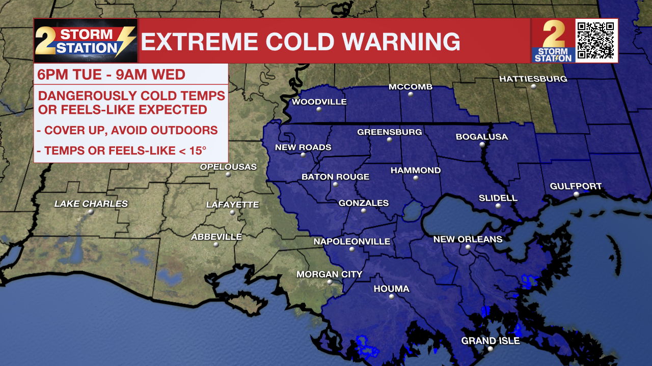
Especially at night, wind chills or feels-like temperatures will be dangerously low, as low as the low teens at times only recovering into the 20s and 30s by day. An Extreme Cold Warning has been issued on Tuesday night ahead of dangerously cold wind chills in the single digits.

As a reminder, starting this season, NWS has changed the cold weather alerts. You will receive different messages to highlight impacts than during previous winters. Review those changes, including the removal of Hard Freeze Warnings, HERE.
Up Next: Temperatures will gradually warm through the rest of the week. Even so, lows will stay below freezing with highs remaining the 40s on most days. Highs above freezing will help to slowly melt leftover snow and ice. Most of it should be gone by the weekend. By next weekend and early next week, highs will inch closer to the 70° mark.
The next chance for precipitation after Tuesday's snow will come next week. Then, it would come in the form of rain.
Get the latest 7-day forecast and real-time weather updates HERE.
Watch live news HERE.
– The Storm Station Meteorologists
The Storm Station is here for you, on every platform. Your weather updates can be found on News 2, wbrz.com, and the WBRZ WX App on your Apple or Android device. Follow WBRZ Weather on Facebook and X for even more weather updates while you are on the go.


