

Latest Weather Blog
Thursday PM Forecast: chilly Halloween with a reinforcing cold front over the weekend
No major impacts are expected over the next seven days as cool temperatures continue. Some nuisance showers may pass over the weekend in association with the next cold front.
Halloween: crisp and quiet
Weekend: passing showers Saturday night, cooler with extra hour of sleep Sunday
Next Week: dry with gradual warming
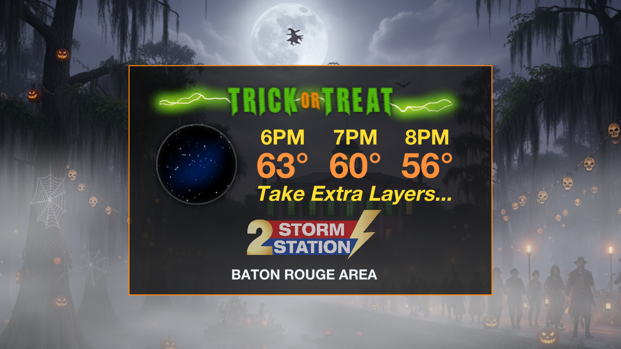
Tonight & Tomorrow: Expect the breezy conditions to gradually subside overnight with lows dipping into the low 40s beneath clear skies. As we turn it over to Halloween, the weather will be ideal for outdoor activity and trick-or-treat time. The afternoon will be cool and sunny with highs in the upper 60s. Into the evening candy collection, thermometers will slide back into the 50s, so make sure those costumes can fit over a layer or two to stay comfortable!
Trending News
Up Next: The dry pattern may be briefly interrupted this weekend as the next cold front approaches. After a chilly beginning in the upper 40s, Saturday will be milder with a high in the low 70s. Clouds will increase late in the day ahead of that front. This boundary may result in a quick hit of showers overnight into early Sunday. Confidence in rain is low as measurable rain is only expected for about 20% of the forecast area. Don't forget, Daylight Saving Time ends on Sunday morning, so you get an extra hour of sleep as we "fall back" on the clocks. Sunday will be a little cooler behind the front with lows in the upper 40s and highs in the upper 60s. Look for plenty of sunshine.
Following the weekend, the new workweek looks quiet and seasonable. Starting Monday and continuing through Thursday, expect mainly clear skies and no chance for rain. Temperatures will work a little warmer each day with lows back to the 50s and highs back to the mid-70s by late week.

The Tropics: On Thursday afternoon, Hurricane Melissa was located about 430 miles west-southwest of Bermuda, moving rapidly toward the northeast at 30 mph. The storm had maximum sustained winds of 105 mph. Conditions in Bermuda will rapidly deteriorate Thursday evening, with hurricane conditions expected overnight as the center of Melissa passes to the northwest of the island. In addition to high winds, the outer bands could bring about an inch of rain, and coastal flooding from storm surge is possible in areas facing onshore winds.
Get the latest 7-day forecast and real-time weather updates HERE.
Watch live news HERE.
– Josh
The Storm Station is here for you, on every platform. Your weather updates can be found on News 2, wbrz.com, and the WBRZ WX App on your Apple or Android device. Follow WBRZ Weather on Facebook and X for even more weather updates while you are on the go.
More News
