

Latest Weather Blog
Wednesday AM Forecast: Foggy start before stormy afternoon, Warm and steamy in-between
Fog may slow your Wednesday morning commute before another round of storms that could impact the evening drive home. Each afternoon through Father’s Day will bring heat, humidity, and scattered storms, so plan outdoor activities with rain in mind.
Today & Tonight: Leftover moisture from Tuesday’s storms may lead to patchy, dense fog around sunrise Wednesday. Visibility could drop to a quarter mile or less during the morning commute, so drivers should use caution. Temperatures will start cooler, in the upper 60s, but will quickly warm under partly sunny skies. Highs around the Capital Area will reach near 90° before any cooling showers arrive. Scattered storms are expected again this afternoon, with about 60% of the 13 Parishes, 2 County Forecast Area likely to see storms that could produce brief, heavy downpours or gusty winds. Storms will taper off by late evening. Mostly cloudy skies tonight will keep lows in the middle to upper 70s early Thursday.
Into the Weekend: With summertime heat and steam plus plenty of moisture in the atmosphere, the forecast is on rinse-and-repeat mode for the rest of the week. Warm, muggy and mainly dry mornings will turn to a mix of sun and clouds through midday, sending highs Thursday and Friday near 90 degrees. The only source of heat relief will be from scattered afternoon storm development.
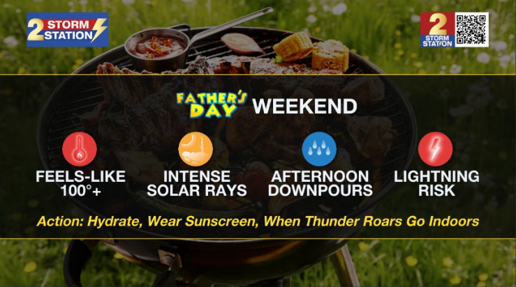
Similar conditions will dominate your Father's Day Weekend forecast, although highs will climb a couple of degrees, likely near 92° each afternoon and feeling closer to 100°+ thanks to humidity. If you are treating dad to a round of golf or grilling out this weekend, watch for brief downpours and passing thunderstorms during the afternoon hours.
Next Week: We will be stuck in a similar weather pattern through the first part of next week. Over the next 7 days, many yards across the Capital Area will pick up 1-3" additional inches of rainfall, with localized higher amounts. There is an early signal that a shift in upper-air pattern will lead to less rain and warmer temperatures by the end of next week.
The Tropics: For the Gulf, Caribbean, and Atlantic, all is quiet. No tropical development is expected over the next seven days.
Trending News
Get the latest 7-day forecast and real-time weather updates HERE.
Watch live news HERE.
– Emma Kate C.
The Storm Station is here for you, on every platform. Your weather updates can be found on News 2, wbrz.com, and the WBRZ WX App on your Apple or Android device. Follow WBRZ Weather on Facebook and X for even more weather updates while you are on the go.
More News
