

Latest Weather Blog
Wednesday AM Forecast: Heat and Storms today, Umbrellas needed through weekend
Wednesday brings a one-two punch of intense heat and numerous storms. Stay safe by staying hydrated and keeping an eye on the forecast as the weather changes throughout the day.
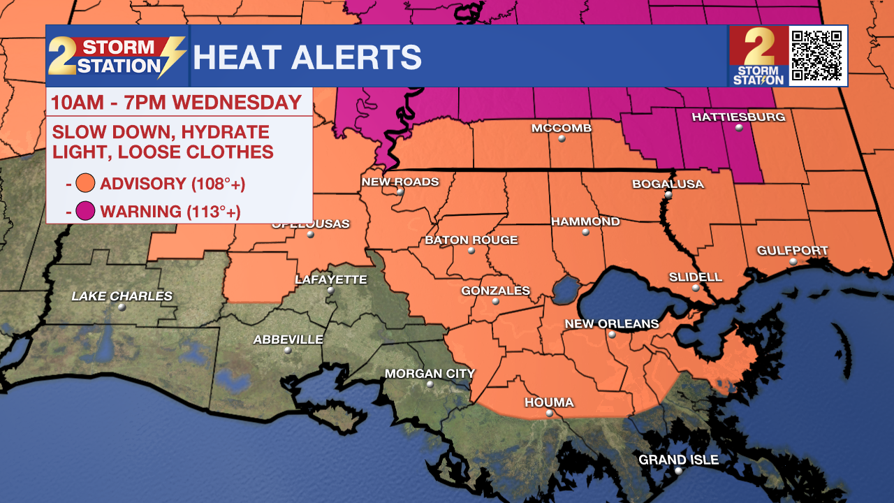
Another Heat Advisory will be in effect for the majority of southeast Louisiana from 10am to 7pm on Wednesday, with the heat index peaking above 108°. Such a mixture of heat and humidity could lead to heat-related illnesses, especially without proper hydration and occasional breaks from the heat.
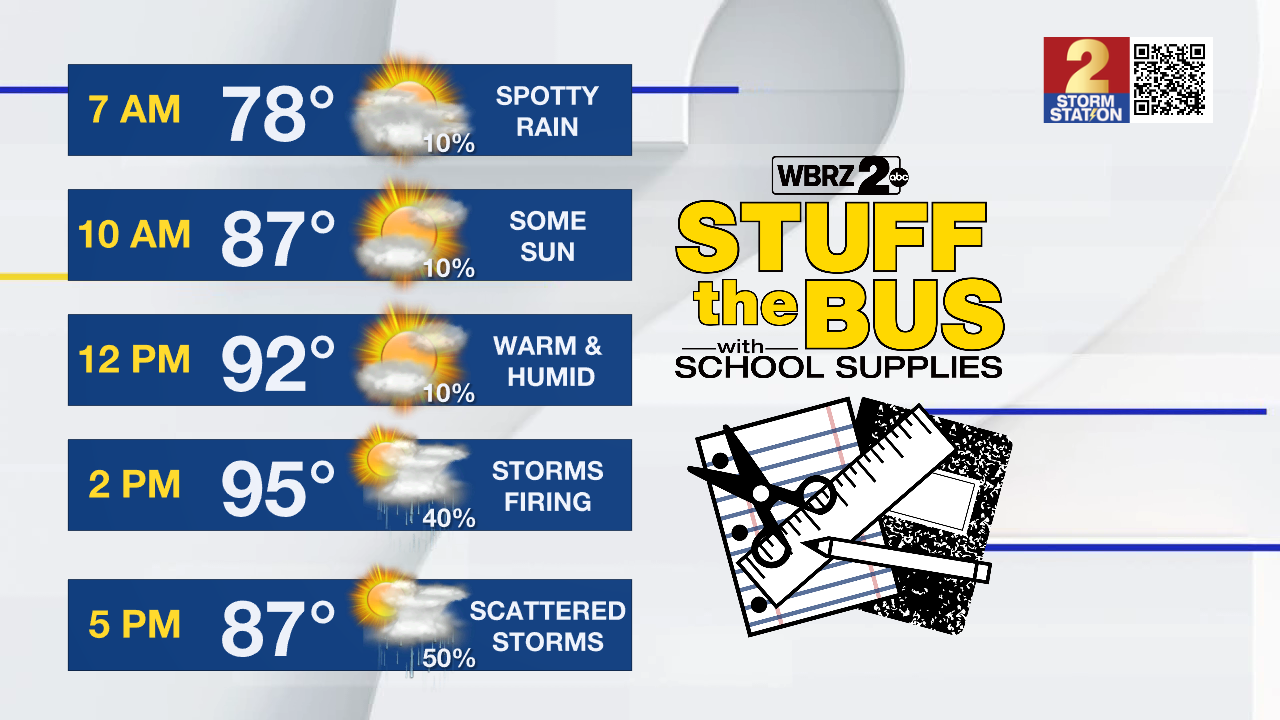
Today & Tonight: Wednesday starts off on a warm and mostly dry note, with temperatures around 80° in Baton Rouge at sunrise. Expect some early sunshine before clouds start building throughout the morning. By midday, scattered storms will begin to pop up across the Capital Region thanks to the return of deep tropical moisture in the atmosphere. While a stray shower or two may sneak in from the coast during the morning, most of the action is expected during the afternoon and evening. Rain coverage will be widespread, with about 80% of the area seeing storms—possibly in more than one round. These storms could bring heavy downpours, frequent lightning and isolated damaging wind gusts. Watch out for storms if you are heading out to donate school supplies for WBRZ's annual Stuff the Bus today!
Before the storms move in, temperatures will climb into the low to mid-90s. With the humidity, it will feel more like 108°, prompting another round of heat alerts for the region. Storms will taper off after sunset as daytime heating fades. Skies will gradually clear overnight, and temperatures will dip into the mid-70s by Thursday morning.
Up Next: With plenty of moisture to tap into, mid to late day rounds of thunderstorms will continue Thursday and Friday. Rain coverage sits at around 70% each day. As is typical for summertime storms, passing downpours, frequent lightning, and brief strong wind gusts will be possible each day. Daytime highs will ease back slightly, warming into the low 90s under a mix of sun and clouds each day before the rain arrives and delivers some relief.
Trending News
Rain chances remain elevated into the weekend as a weak frontal boundary moves into the region from the north early Saturday and stalls over the area for a few days. This setup may trigger additional storms, particularly during the heat of the day. There's also a chance a line of thunderstorms forms along the front and moves through early in the weekend, though confidence in that scenario is still low.
The uptick in rain chances will help hold off any dangerous heat, but the humidity will stick around. Highs will hover near average, close to 92° each day, but thick air will keep it feeling warmer. If you have outdoor plans this weekend, it’s wise to keep an eye on radar and have a backup option ready.
The Tropics: For the Gulf, Caribbean, and North Atlantic, all is quiet. No tropical development is expected during the next 7 days.
Get the latest 7-day forecast and real-time weather updates HERE.
Watch live news HERE.
– Emma Kate C.
The Storm Station is here for you, on every platform. Your weather updates can be found on News 2, wbrz.com, and the WBRZ WX App on your Apple or Android device. Follow WBRZ Weather on Facebook and X for even more weather updates while you are on the go.
More News
