

Latest Weather Blog
Wednesday PM Forecast: rain has returned and will remain part of forecast into weekend
Rain has returned to the Capital Area. Keep an umbrella around for the next several days and be ready for some slick or slow commutes—especially during the afternoons and evenings.
Thursday & Friday: warm, pop-up afternoon showers and thunderstorms
Weekend: dodging rain and thunderstorms
Early Next Week: slight lull in showers

Use the slider to advance through the next 24 hours of Futurecast
Trending News
Tonight & Tomorrow: Showers will taper quickly through the evening hours. Though there may be some clearing early, clouds will thicken up again after midnight with some patchy fog even possible near dawn. Low temperatures will stop in the mid 60s. By mid-morning on Thursday, a little bit of sun will break through the clouds. High temperatures will top out in the low 80s by early afternoon. Not as many locations will get rain on Thursday, but isolated showers and thunderstorms will pop up during the second half of the day. About 30% of the 13 Parish, 2 County Storm Station Forecast Area will receive rain, with quick downpours leaving behind a half inch or so. Some of the showers could linger into the afternoon commute, so be prepared for slick spots.

Up Next: Though no total washouts are ahead, the weather pattern will remain wet and unsettled. Friday, Saturday and Sunday rain coverage will bump up into the 40 - 70% range. A weak front will try to push into our area from the north. It will never get here to bring cooler air, but it will be close enough to add a little extra trigger for showers and thunderstorms, especially when paired with daytime warming as temperatures hit the 80s.
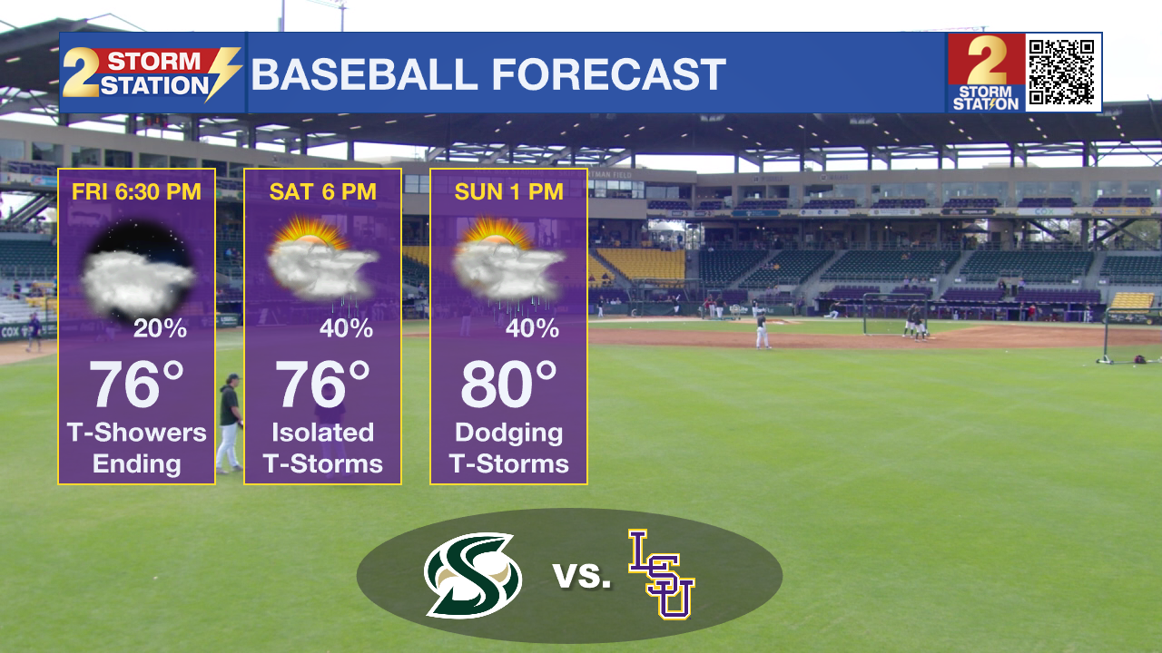
The weather could be touch-and-go for LSU Baseball. Since games on Friday and Saturday will start during the evening hours, most of the activity should be wrapping up but some showers could certainly linger. Sunday could be a different story since the game is scheduled for afternoon which will be the most favorable time for showers and thunderstorms.
Through the weekend, while overall rain totals will stay manageable at 1-2”, a few localized spots could see a downpour exceeding that, which would generally be beneficial for thirsty lawns and gardens. Any outdoor events and plans will need to keep tabs on the radar via the Storm Station Weather App and have an indoor break option in case of passing storms.
Lastly, morning fog will still be possible over the next several days due to added moisture streaming in from the Gulf. The most likely spots to have reduced visibility would be near bodies of water, so be ready to occasionally slow it down and use low beam headlights if you hit one of these patches.
Next week will start off just a little bit quieter, with more places getting some dry time. It will remain warm with high temperatures getting well into the 80s. There are signs of a cold front chopping across the region around the middle of the week, with another inch or so of rain due to thunderstorms, followed by cooler temperatures.
Get the latest 7-day forecast and real-time weather updates HERE.
Watch live news HERE.
– Josh
The Storm Station is here for you, on every platform. Your weather updates can be found on News 2, wbrz.com, and the WBRZ WX App on your Apple or Android device. Follow WBRZ Weather on Facebook and X for even more weather updates while you are on the go.
More News
