

Latest Weather Blog
Monday PM Forecast: Fewer storms, more heat for the first week of summer
Rain is no longer the main story; it’s heat. That familiar mix of Louisiana heat and thick humidity will firmly establish its presence for the first week of summer. Storms will also become harder to find, though some days will still offer a better chance for a quick downpour than others.
Tonight & Tomorrow: Expect partly cloudy skies into Monday morning with lows bottoming out in the mid-70s. During the evening, a stalled frontal system will trigger a batch of thunderstorms near the I-20 corridor. Any storms that meander south will weaken, leaving nothing more than a slim chance for a stray, early-morning shower north of I-12.
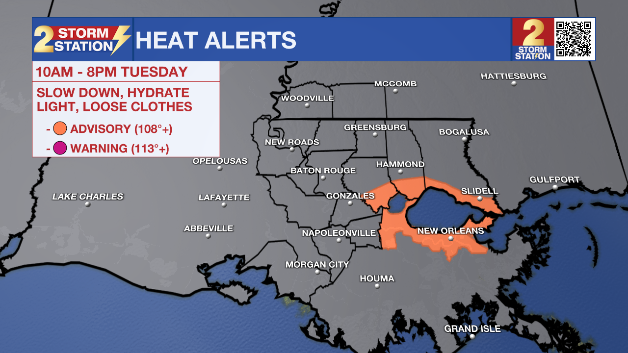
The rest of Tuesday brings a mixture of clouds and sun with highs soaring into the low to mid-90s. A spot shower or thunderstorm cannot be ruled out, especially north and east of Baton Rouge, but don’t count on rain to cool things off. Summer humidity will place the peak feels-like temperature around 105°, just a few degrees shy of Heat Advisory criteria (108°) in the Capital Area. However, areas near bodies of water will experience extra stickiness in the air. The added moisture could nudge heat index values beyond that Heat Advisory threshold. For that reason, the National Weather Service has issued a Heat Advisory for areas around Lake Pontchartrain from 10 a.m. to 8 p.m. Tuesday. Be sure to drink plenty of water and limit strenuous activities during the hottest part of the day. Always listen to your body, and if you notice any signs of heat illness, stop what you are doing immediately to cool down and take action.
Up Next: Summer heat will not let up around midweek, though rain chances will be just a touch higher in the Wednesday/Thursday timeframe. Rain timing will hinge on the development of storms to the north, eventually drifting south toward I-10. Unfortunately, pinpointing the exact timing and how many neighborhoods see rain remains tricky until these storms actually develop. The Storm Station will track this changing situation over the coming days. At this time, the atmosphere appears to support such a scenario around midweek.

Toward the end of the week, a ridge of high pressure will take over and effectively slam the door on stormy weather. Heat will dominate the weekend with daytime highs holding steady in the mid-90s and nighttime lows offering brief heat relief in the mid-70s. The ridge will grow even stronger next week, which could easily push afternoon highs into the upper 90s for the first time this season. Keep those sunglasses handy and remember to practice heat safety while spending time out on the water or firing up the grill.
Trending News

Get the latest 7-day forecast and real-time weather updates HERE.
Watch live news HERE.
The Tropics: No tropical development is expected across the North Atlantic, Caribbean, or Gulf over the next seven days.
— Meteorologist Malcolm Byron
The Storm Station is here for you, on every platform. Your weather updates can be found on News 2, wbrz.com, and the WBRZ WX App on your Apple or Android device. Follow WBRZ Weather on Facebook and X for even more weather updates while you are on the go.
More News
