

Latest Weather Blog
Monday AM forecast: Storms Return Today, Some Severe
After a stretch of dangerous heat, a much wetter pattern is taking over south Louisiana this week. Scattered to numerous showers and thunderstorms are expected each afternoon, with Monday bringing the greatest coverage and the potential for some storms to produce damaging wind gusts and very heavy rain.

Today and Tonight: Monday is shaping up to be the most impactful weather day of the week so far. A disturbance moving into the region will help thunderstorms develop around midday and continue through the afternoon. Storm coverage could become fairly widespread, with some forecast models suggesting a larger cluster of storms developing across south Louisiana. Some severe weather is possible.

Use the slider to advance through the next 24 hours of Futurecast
Trending News
Despite the storm threat, it will still be hot ahead of the storms. Temperatures should climb into the middle 90s before thunderstorms develop, with heat index values potentially reaching around 108 degrees for a short time. No Heat Advisory is currently in effect because the expected storms should bring fairly quick relief from the heat.
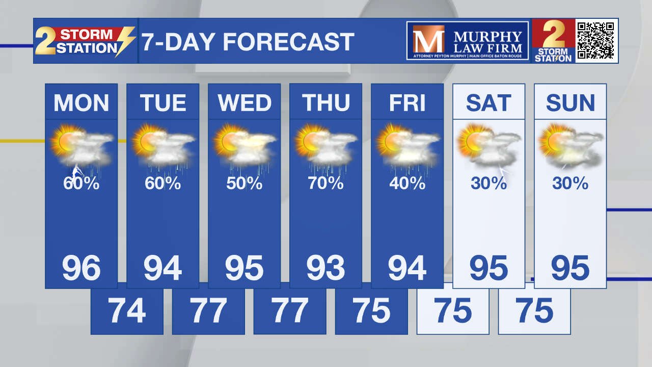
Up Next: The wet pattern continues Tuesday through Thursday, with scattered to numerous showers and thunderstorms possible each afternoon. The good news is that more clouds and rain will provide some relief from the prolonged heat. Outside of brief periods before storms develop, temperatures should have a harder time reaching the upper 90s seen recently.
Tropics: There are no tropical threats currently expected to impact the Gulf. The National Hurricane Center is monitoring a low-pressure area several hundred miles southeast of Bermuda. The system has a 50% chance of becoming a tropical depression or tropical storm during the next couple of days, but it is expected to move north and northeast, well away from the Gulf Coast.

Another tropical wave is expected to move off the coast of Africa later today. Some development could occur later this week as it moves westward across the Atlantic. The system currently has a 50% chance of tropical development over the next seven days, so it is something to watch but is not an immediate concern for Louisiana.
Get the latest 7-day forecast and real-time weather updates HERE.
Watch live news HERE.
– Dave
The Storm Station is here for you, on every platform. Your weather updates can be found on News 2, wbrz.com, and the WBRZ WX App on your Apple or Android device. Follow WBRZ Weather on Facebook and X for even more weather updates while you are on the go.
More News

