

Latest Weather Blog
Sunday PM Forecast: Summer's not done, but gusty storms likely to bring cooling relief
After weeks of intense heat, a pattern shift will bring some welcome relief. Though summer isn't quite done yet, a boost in storm activity will help take the edge off the heat.
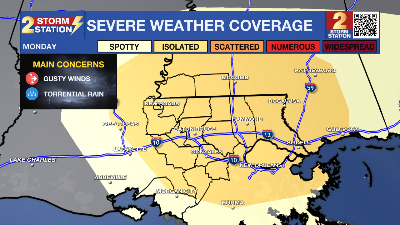
Tonight & Tomorrow: Sunday’s isolated thunderstorms will quickly fade during the evening. Expect mostly clear skies overnight, with humid and unseasonably warm conditions remaining in place. Look for a morning low in the upper 70s. Although Monday begins with sunshine, clouds will start spilling into the region by midday. The afternoon will turn mostly cloudy as a wave of deeper moisture arrives out of the northwest, fueling scattered showers and thunderstorms in the process. Moving from north to south, these storms will drop rain on just over half of the area.

Use the slider to advance through the next 24 hours of Futurecast
A few cells could turn severe, bringing localized damaging wind gusts up to 60 mph. A Level 2/5 severe weather risk is in place to address that, so make sure notifications are turned on in your Storm Station Weather App to stay ahead of any nasty weather. Additionally, heavy rain will wet roadways and could overlap with the lunch rush and/or evening drive. Prepare accordingly for possible driving delays.
One big silver lining to the boost in cloud cover and storm chances is some long-awaited heat relief. Expect highs in the mid-90s ahead of the storms, followed by a temperature tumble as clouds shield sunlight and rain-cooled air spreads south. While the heat index, or feels-like temperature, could flirt with 108° around lunchtime, it probably won’t stay that way all afternoon. No Heat Advisory has been issued for Monday just yet. If storms fire up early enough, rain-cooled air may keep heat index values below advisory criteria altogether.
Up Next: Leftover moisture through midweek will allow for more scattered shower and storm activity. While not a constant soak, and likely plenty hot beforehand, this rain would continue to offer up some heat relief. The best rain chance of the week might come on Thursday as an upper-level disturbance glides into the region and squeezes out even more storms. Daily storm coverage will start to taper off toward next weekend, setting the stage for building heat once again. Most will pick up 1-2” of rainfall over the next week, with isolated areas pushing 3”.
Trending News

Get the latest 7-day forecast and real-time weather updates HERE.
Watch live news HERE.
The Tropics: Satellite images in the Central Subtropical Atlantic show some signs of organization with an area of low pressure located roughly 400 miles southeast of Bermuda. Further development of this system is possible, and it might become a short-lived tropical depression or storm during the next couple of days while moving northward through the Atlantic. This area of interest will not be a threat to the United States.
Meanwhile, a tropical wave will move off the west coast of Africa on Monday. There will be some favorable environmental conditions for development early in the week, and a tropical depression might form toward mid-to-late week as it moves west through the tropical Atlantic. This system will pose no threat to the Gulf Coast.

— Meteorologist Malcolm Byron
The Storm Station is here for you, on every platform. Your weather updates can be found on News 2, wbrz.com, and the WBRZ WX App on your Apple or Android device. Follow WBRZ Weather on Facebook and X for even more weather updates while you are on the go.
More News

